Red Arrows Tracker — 2026 Flight Paths & Display Routes
NOTAM-based Red Arrows flight paths, display locations, formation routes and timing windows for the 2026 season. Select an event below to see today's route, waypoints and display times. Not a live tracker — for real-time aircraft positions use FlightRadar24 or ADS-B Exchange.
This is an unofficial, personal fan site — not a live tracker. It brings together official Red Arrows display schedules, information derived from UK NOTAMs, and relevant public updates. Routes and timings can change at any time and nothing shown here is guaranteed.
Transit routes waypoints and locations - Unless stated, these are not displays or flypasts. Use this as a loose planning aid only — not a basis for travel or commitment.
Why this site exists. To bring fragmented public aviation information together to help enthusiasts understand when the Red Arrows may be operating nearby.
Transit routes are not displays. Aircraft may be at altitude, on a different track, or invisible from the ground. No smoke, no formation break. Sightings are never guaranteed.
Everything here can change — at any time. Routes and timings may be altered at short notice, sometimes while already airborne.
Do not make travel commitments based on this site alone. Information is provided in good faith but nothing is confirmed.
This is not a live tracker. For live positions use FlightRadar24 or ADS-B Exchange.
For confirmed events, check the official Red Arrows website.
Do not contact the Red Arrows team based on anything here. The RAF team have no involvement with this fan site.
Check the Next 7 Days tab.
* No NOTAMs available for tours outside of UK.
Timings are estimates derived from pre-filed NOTAM data and other online resources and are liable to change without prior notice — changes will likely not be reflected here. For the most accurate details check the official event website (if applicable) and Red Arrows social media — links are below. See also: About this site.
The Red Arrows departed EAST MIDLANDS (EGNX) via 13 possible waypoints, displaying over RAF COSFORD DISPLAY before arriving at RAF WADDINGTON (EGXW).
Tap a marker for details · click a table row to highlight on map.| Possible Waypoint Location | Time (BST) |
|---|---|
| EAST MIDLANDS (EGNX) | 14:48 |
| West RISLEY | 14:50 |
| South-West of STOKE ON TRENT | 14:56 |
| North LILLESHALL | 14:57 |
| Vicinity ABBEY WOOD | 14:58 |
| Vicinity COSFORD | 14:59 |
| RAF COSFORD DISPLAY Display | 15:00 |
| North WOMBOURNE | 15:21 |
| North LICHFIELD | 15:23 |
| Vicinity MELTON MOWBRAY | 15:29 |
| Vicinity NEWARK ON TRENT | 15:32 |
| Vicinity WHISBY | 15:34 |
| RAF WADDINGTON (EGXW) | 15:35 |
Timings are estimates derived from pre-filed NOTAM data and other online resources and are liable to change without prior notice — changes will likely not be reflected here. For the most accurate details check the official event website (if applicable) and Red Arrows social media — links are below. See also: About this site.
A formation transit from RAF WADDINGTON (EGXW) to EAST MIDLANDS (EGNX) via 30 possible waypoints.
A formal flypast is indicated on this route (BUCKINGHAM PALACE ~13:06 BST). A waypoint marked FP indicates a formal flypast is planned at that location — these are generally more likely to be visible than standard transit waypoints, but are still not displays.
Tap a marker for details · click a table row to highlight on map.| Possible Waypoint Location | Time (BST) |
|---|---|
| RAF WADDINGTON (EGXW) | 12:27 |
| Vicinity METHERINGHAM | 12:29 |
| Vicinity GREAT HALE | 12:31 |
| OVERSEA | 12:41 |
| North-East CAISTER ON SEA | 12:46 |
| Vicinity LOWERSOFT | 12:48 |
| OVERSEA | 12:51 |
| Vicinity WOODBRIDGE AIRFIELD | 12:54 |
| Vicinity COLCHESTER | 12:58 |
| Vicinity LOFT HALL | 13:03 |
| Vicinity FAIRLOP | 13:04 |
| Vicinity TEMPLE MILLS | 13:05 |
| BUCKINGHAM PALACE Flypast | 13:06 |
| Vicinity BELGRAVIA | 13:07 |
| Vicinity BRENTFORD END | 13:08 |
| Vicinity LONDON HEATHROW | 13:10 |
| Vicinity BEACONSFIELD | 13:11 |
| Vicinity NAPHILL | 13:12 |
| Vicinity LOOSELY ROW | 13:13 |
| Vicinity WENDOVER | 13:14 |
| North LONG MARSTON | 13:15 |
| Vicinity BURCOTT HALL | 13:16 |
| Vicinity BLETCHLEY | 13:17 |
| Vicinity MILTON KEYNES | 13:18 |
| Vicinity RUTLAND WATER | 13:24 |
| Vicinity KENDREW BARRACKS | 13:25 |
| North STOKE ROCHFORD | 13:27 |
| Vicinity HARLAXTON | 13:28 |
| Vicinity SHEPSHED | 13:32 |
| EAST MIDLANDS (EGNX) | 13:33 |
Timings are estimates derived from pre-filed NOTAM data and other online resources and are liable to change without prior notice — changes will likely not be reflected here. For the most accurate details check the official event website (if applicable) and Red Arrows social media — links are below. See also: About this site.
The Red Arrows carried out a flypast over Lincoln within a 5 NM restricted area.
Tap a marker for details · click a table row to highlight on map.Timings are estimates derived from pre-filed NOTAM data and other online resources and are liable to change without prior notice — changes will likely not be reflected here. For the most accurate details check the official event website (if applicable) and Red Arrows social media — links are below. See also: About this site.
The Red Arrows departed and returned to RAF WADDINGTON (EGXW), routing via 17 possible waypoints to display over Silverstone.
Tap a marker for details · click a table row to highlight on map.| Possible Waypoint Location | Time (BST) |
|---|---|
| RAF WADDINGTON (EGXW) | 15:13 |
| Vicinity WHISBY | 15:15 |
| Vicinity GOADBY MARWOOD | 15:18 |
| North-East of HARPOLE | 15:24 |
| North-East of PRIORS MARSTON | 15:26 |
| West of MIDDLETON CHENEY | 15:27 |
| North of HALSE | 15:28 |
| DISPLAY (Silverstone) Display | 15:30 |
| Vicinity SILVERSTONE | 15:30 |
| Vicinity COSGROVE | 15:51 |
| Vicinity BRIXWORTH | 15:53 |
| North of WHISSENDINE | 15:57 |
| North-East of SWINSTEAD | 15:59 |
| East of OASBY | 16:01 |
| Vicinity RAF CRANWELL | 16:02 |
| Vicinity WHISBY | 16:03 |
| RAF WADDINGTON (EGXW) | 16:04 |
Timings are estimates derived from pre-filed NOTAM data and other online resources and are liable to change without prior notice — changes will likely not be reflected here. For the most accurate details check the official event website (if applicable) and Red Arrows social media — links are below. See also: About this site.
UPDATE: NOTAM ISSUED FOR 1400 BST DEPARTURE - (Select the new entry (1400-1430) for details).
A formation transit from RAF VALLEY (EGOV) to RAF WADDINGTON (EGXW) via 11 possible waypoints.
Tap a marker for details · click a table row to highlight on map.| Possible Waypoint Location | Time (BST) |
|---|---|
| RAF VALLEY (EGOV) | 11:30 |
| OVERSEA | 11:32 |
| Vicinity CAERNARFON | 11:34 |
| North-West COED Y RHYGEN | 11:37 |
| North-East of PENTRE LLAWEN | 11:40 |
| North-West of NANT | 11:42 |
| North-East of SANDBACH | 11:48 |
| East of LEEK | 11:50 |
| North of BUDBY | 11:55 |
| West of WHISBY | 11:58 |
| RAF WADDINGTON (EGXW) | 12:00 |
Timings are estimates derived from pre-filed NOTAM data and other online resources and are liable to change without prior notice — changes will likely not be reflected here. For the most accurate details check the official event website (if applicable) and Red Arrows social media — links are below. See also: About this site.
A formation transit from RAF VALLEY (EGOV) to RAF WADDINGTON (EGXW) via 11 possible waypoints.
Tap a marker for details · click a table row to highlight on map.| Possible Waypoint Location | Time (BST) |
|---|---|
| RAF VALLEY (EGOV) | 14:00 |
| OVERSEA | 14:02 |
| Vicinity CAERNARFON | 14:04 |
| North-West COED Y RHYGEN | 14:07 |
| North-East of PENTRE LLAWEN | 14:10 |
| North-West of NANT | 14:12 |
| North-East of SANDBACH | 14:18 |
| East of LEEK | 14:20 |
| North of BUDBY | 14:25 |
| West of WHISBY | 14:28 |
| RAF WADDINGTON (EGXW) | 14:30 |
Timings are estimates derived from pre-filed NOTAM data and other online resources and are liable to change without prior notice — changes will likely not be reflected here. For the most accurate details check the official event website (if applicable) and Red Arrows social media — links are below. See also: About this site.
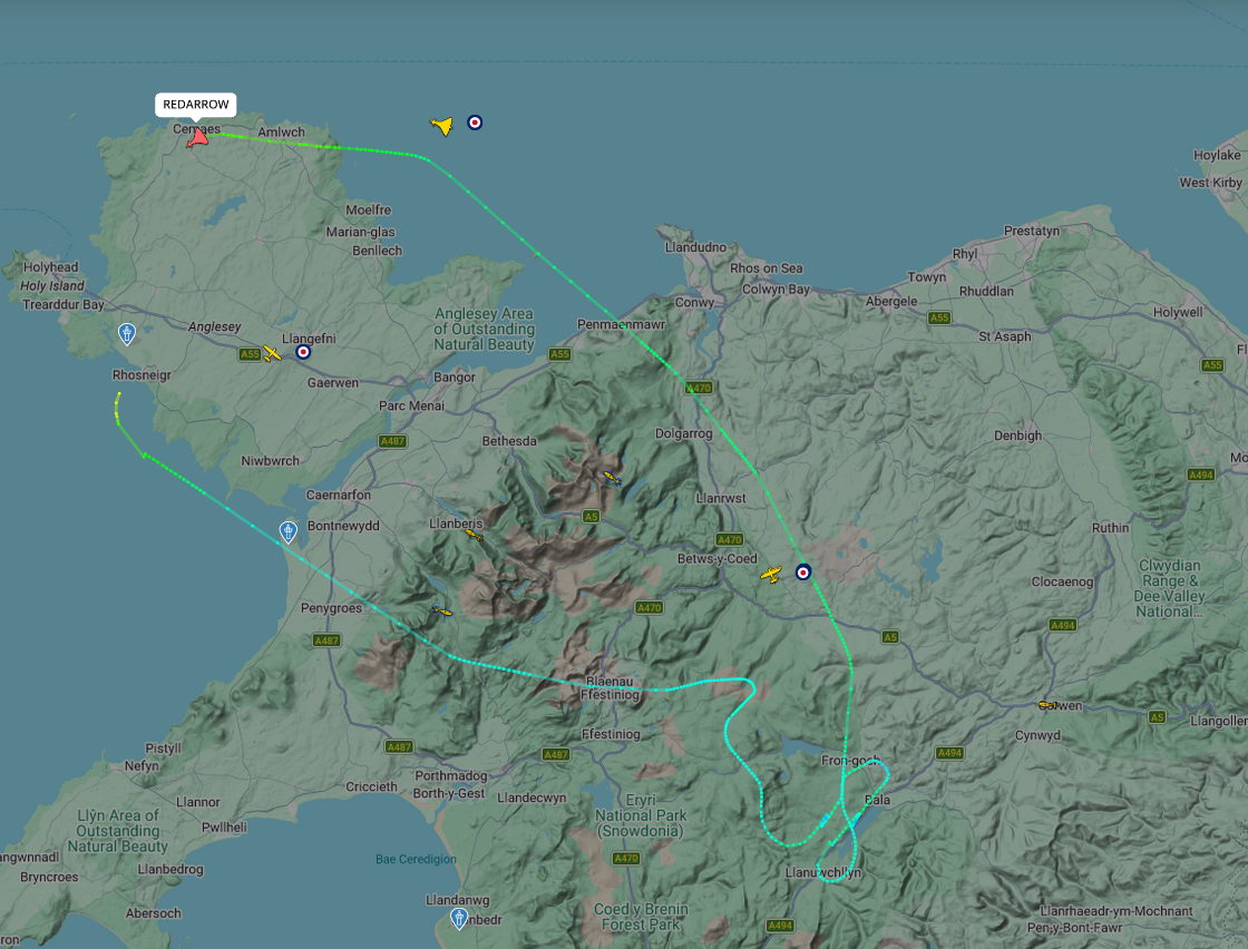
A formation transit from RAF WADDINGTON to RAF VALLEY via 8 possible waypoints.
Tap a marker for details · click a table row to highlight on map.| Possible Waypoint Location | Time (BST) |
|---|---|
| RAF WADDINGTON | 15:29 |
| Vicinity of BLANKNEY | 15:31 |
| Vicinity of MAYTHORNE | 15:34 |
| Vicinity of HOLT | 15:46 |
| North of BWLCH DDEUFAEN | 15:52 |
| South-West of NIWBWRCH | 15:55 |
| OVER SEA | 15:57 |
| RAF VALLEY | 15:58 |
Timings are estimates derived from pre-filed NOTAM data and other online resources and are liable to change without prior notice — changes will likely not be reflected here. For the most accurate details check the official event website (if applicable) and Red Arrows social media — links are below. See also: About this site.
The Red Arrows departed and returned to RAF VALLEY, routing via 10 possible waypoints to display over Douglas Bay.
Tap a marker for details · click a table row to highlight on map.| Possible Waypoint Location | Time (BST) |
|---|---|
| RAF VALLEY | 19:13 |
| OVERSEA | 19:15 |
| OVERSEA | 19:22 |
| OVERSEA | 19:24 |
| OVERSEA | 19:27 |
| Vicinity of RHENNY | 19:29 |
| DISPLAY (Douglas Bay) Display | 19:30 |
| OVERSEA | 19:50 |
| North of BETHAL | 19:51 |
| RAF VALLEY | 20:00 |
Timings are estimates derived from pre-filed NOTAM data and other online resources and are liable to change without prior notice — changes will likely not be reflected here. For the most accurate details check the official event website (if applicable) and Red Arrows social media — links are below. See also: About this site.
The Red Arrows departed EAST MIDLANDS AIRPORT via 13 possible waypoints, displaying over MIDLANDS AIR FEST DISPLAY before arriving at RAF WADDINGTON.
Tap a marker for details · click a table row to highlight on map.⚠ Time anomaly — all waypoint times shown as ??:?? — see note below.
| Display restriction NOTAM | 16:25–17:05 UTC (17:25–18:05 BST) — filed in UTC as normal ✓ |
| Formation NOTAM waypoint | 18:30 — appears filed in BST, not UTC ⚠ |
| Possible Waypoint Location | Time (BST) |
|---|---|
| EAST MIDLANDS AIRPORT ⚠ | ??:?? (NOTAM: 18:18) |
| North-East of WHITWICK ⚠ | ??:?? (NOTAM: 18:20) |
| North of RUGBY ⚠ | ??:?? (NOTAM: 18:23) |
| North of LIGHTHORNE ⚠ | ??:?? (NOTAM: 18:26) |
| North-West of REDDITCH ⚠ | ??:?? (NOTAM: 18:28) |
| Vicinity of REDDITCH ⚠ | ??:?? (NOTAM: 18:29) |
| MIDLANDS AIR FEST DISPLAY Display ⚠ | ??:?? (NOTAM: 18:30) Restriction window 17:25–18:05 BST likely more reliable — check official schedule. |
| East of EVESHAM ⚠ | ??:?? (NOTAM: 18:51) |
| East of ILMINGTON ⚠ | ??:?? (NOTAM: 18:52) |
| West of DAVENTRY ⚠ | ??:?? (NOTAM: 18:56) |
| South of MARKET HARBOROUGH ⚠ | ??:?? (NOTAM: 18:58) |
| North of THORPE ON THE HILL ⚠ | ??:?? (NOTAM: 19:06) |
| RAF WADDINGTON ⚠ | ??:?? (NOTAM: 19:07) |
Timings are estimates derived from pre-filed NOTAM data and other online resources and are liable to change without prior notice — changes will likely not be reflected here. For the most accurate details check the official event website (if applicable) and Red Arrows social media — links are below. See also: About this site.
The Red Arrows departed and returned to EXETER, routing via 10 possible waypoints to display over TORBAY DISPLAY.
Tap a marker for details · click a table row to highlight on map.| Possible Waypoint Location | Time (BST) |
|---|---|
| EXETER | 11:45 |
| South-West of BRADNINCH | 11:47 |
| North of ROADFORD LAKE | 11:52 |
| West of BERE ALSTON | 11:55 |
| Vicinity OT TOTNES | 11:59 |
| TORBAY DISPLAY Display | 12:00 |
| OVERSEA | 12:21 |
| North of SIDMOUTH | 12:24 |
| South-West of BRADNINCH | 12:26 |
| EXETER | 12:28 |
Timings are estimates derived from pre-filed NOTAM data and other online resources and are liable to change without prior notice — changes will likely not be reflected here. For the most accurate details check the official event website (if applicable) and Red Arrows social media — links are below. See also: About this site.
A formation transit from EXETER to EAST MIDLANDS AIRPORT via 13 possible waypoints.
A formal flypast is indicated on this route (UPPER WARDINGTON ~14:54 BST). A waypoint marked FP indicates a formal flypast is planned at that location — these are generally more likely to be visible than standard transit waypoints, but are still not displays.
Tap a marker for details · click a table row to highlight on map.⚠ Time anomaly — affected waypoints shown as ??:??
One waypoint goes backwards in time relative to the preceding waypoint, suggesting a possible data entry error in the source NOTAM.
— S OF SHEPTON MALLET published 14:40 BST, 4 minutes before SE OF TIVERTON (14:44 BST).
Affected waypoints are shown as ??:?? on the map and highlighted in the route table below.
Possible NOTAM time input error: waypoints "S OF SHEPTON MALLET" (published 14:40 BST) and "W OF WINSLEY" (published 14:42 BST) appear out of sequence — both fall before the preceding waypoint at 14:44 BST. "SE OF QUEMERFORD" (published 14:45 BST) is also flagged. All three are shown as ??:?? on the map and route table. The sequence appears to resume correctly from N OF WOODMANCOTE at 14:48 BST.
| Possible Waypoint Location | Time (BST) |
|---|---|
| EXETER | 14:41 |
| South-West of BRADNINCH | 14:43 |
| South-East of TIVERTON | 14:44 |
| South of SHEPTON MALLET ⚠ Time error? | ??:?? (NOTAM: 14:40) Likely within ~14:44–14:48 BST — actual time unknown |
| West of WINSLEY ⚠ Time error? | ??:?? (NOTAM: 14:42) Likely within ~14:44–14:48 BST — actual time unknown |
| South-East of QUEMERFORD ⚠ Time error? | ??:?? (NOTAM: 14:45) Likely within ~14:44–14:48 BST — actual time unknown |
| North of WOODMANCOTE | 14:48 |
| South-East of SHUTFORD | 14:53 |
| UPPER WARDINGTON Flypast | 14:54 |
| East of FARTHINGSTONE | 14:55 |
| Vicinity of RATBY | 15:00 |
| South of EAST LEAKE | 15:02 |
| EAST MIDLANDS AIRPORT | 15:03 |
Timings are estimates derived from pre-filed NOTAM data and other online resources and are liable to change without prior notice — changes will likely not be reflected here. For the most accurate details check the official event website (if applicable) and Red Arrows social media — links are below. See also: About this site.
The Red Arrows departed and returned to EAST MIDLANDS AIRPORT, routing via 13 possible waypoints to display over MIDLANDS AIR FEST DISPLAY.
Tap a marker for details · click a table row to highlight on map.| Possible Waypoint Location | Time (BST) |
|---|---|
| EAST MIDLANDS AIRPORT | 17:48 |
| North-East of WHITWICK | 17:50 |
| North of RUGBY | 17:53 |
| North of LIGHTHORNE | 17:56 |
| North-West of REDDITCH | 17:58 |
| Vicinity of REDDITCH | 17:59 |
| MIDLANDS AIR FEST DISPLAY Display | 18:00 |
| East of EVESHAM | 18:21 |
| West of TREDINGTON | 18:22 |
| North-East of KINETON | 18:24 |
| North-East of CLIFTON UPON DUNSMORE | 18:27 |
| North of BREASTON | 18:32 |
| EAST MIDLANDS AIRPORT | 18:33 |
Timings are estimates derived from pre-filed NOTAM data and other online resources and are liable to change without prior notice — changes will likely not be reflected here. For the most accurate details check the official event website (if applicable) and Red Arrows social media — links are below. See also: About this site.
A formation transit from RAF WADDINGTON to EXETER via 20 possible waypoints.
A formal flypast is indicated on this route (BRIZE NORTON ~14:10 BST). A waypoint marked FP indicates a formal flypast is planned at that location — these are generally more likely to be visible than standard transit waypoints, but are still not displays.
Tap a marker for details · click a table row to highlight on map.| Possible Waypoint Location | Time (BST) |
|---|---|
| RAF WADDINGTON | 13:48 |
| South-East of METHRINGHAM | 13:50 |
| North of HECKINGTON | 13:52 |
| South-West of GOSBERTON CLOUGH | 13:53 |
| MOULTEN SEAS END | 13:54 |
| South of SUTTON ST JAMES | 13:56 |
| South of WOOTTON | 14:04 |
| North-West of BLOXHAM | 14:07 |
| South-West of CHARLBURY | 14:09 |
| BRIZE NORTON Flypast | 14:10 |
| South-West of CLANFIELD | 14:11 |
| North-West of UPPER LAMBOUORN | 14:12 |
| LYNEHAM | 14:15 |
| CHITTOE | 14:16 |
| Vicinity of BRADFORD UPON AVON | 14:17 |
| West of NUNNEY | 14:19 |
| South of STURMINSTER NEWTON | 14:22 |
| South of AXMINSTER | 14:27 |
| South-West of BRADNINCH | 14:29 |
| EXETER | 14:30 |
Timings are estimates derived from pre-filed NOTAM data and other online resources and are liable to change without prior notice — changes will likely not be reflected here. For the most accurate details check the official event website (if applicable) and Red Arrows social media — links are below. See also: About this site.
The Red Arrows departed and returned to EXETER, routing via 10 possible waypoints to display over TORBAY DISPLAY.
Tap a marker for details · click a table row to highlight on map.| Possible Waypoint Location | Time (BST) |
|---|---|
| EXETER | 18:30 |
| South-West of BRADNINCH | 18:32 |
| North of ROADFORD LAKE | 18:37 |
| West of BERE ALSTON | 18:40 |
| Vicinity OT TOTNES | 18:44 |
| TORBAY DISPLAY Display | 18:45 |
| OVERSEA | 19:06 |
| North of SIDMOUTH | 19:09 |
| South-West of BRADNINCH | 19:11 |
| EXETER | 19:13 |
Timings are estimates derived from pre-filed NOTAM data and other online resources and are liable to change without prior notice — changes will likely not be reflected here. For the most accurate details check the official event website (if applicable) and Red Arrows social media — links are below. See also: About this site.
A formation transit that departed and returned to RAF WADDINGTON via 11 possible waypoints.
A formal flypast is indicated on this route (WARMSWORTH ~09:43 BST). A waypoint marked FP indicates a formal flypast is planned at that location — these are generally more likely to be visible than standard transit waypoints, but are still not displays.
Tap a marker for details · click a table row to highlight on map.| Possible Waypoint Location | Time (BST) |
|---|---|
| RAF WADDINGTON | 09:35 |
| North of THORPE ON THE HILL | 09:37 |
| North of MAPLEBECK | 09:39 |
| Vicinity of CLUMBER PARK | 09:40 |
| South-East of CARLTON LINDRICK | 09:41 |
| South-West of TICKHILL | 09:42 |
| WARMSWORTH Flypast | 09:43 |
| West of ADWICK LE STREET | 09:44 |
| SAXBY ALL SAINTS | 09:48 |
| POTTERHANWORTH | 09:53 |
| RAF WADDINGTON | 09:54 |
Timings are estimates derived from pre-filed NOTAM data and other online resources and are liable to change without prior notice — changes will likely not be reflected here. For the most accurate details check the official event website (if applicable) and Red Arrows social media — links are below. See also: About this site.
A formation transit from RAF WADDINGTON to RAF CONINGSBY via 10 possible waypoints.
Tap a marker for details · click a table row to highlight on map.| Possible Waypoint Location | Time (BST) |
|---|---|
| RAF WADDINGTON | 09:15 |
| WHISBY | 09:17 |
| East of STURTON LE STEEPLE | 09:19 |
| North-West of ALKBOROUGH | 09:22 |
| East of YORK | 09:26 |
| North-East of RILLINGTON | 09:28 |
| Vicinity of SCARBOROUGH | 09:30 |
| Vicinity of HEDON | 09:35 |
| North of WOODHALL SPA | 09:41 |
| RAF CONINGSBY | 09:43 |
Timings are estimates derived from pre-filed NOTAM data and other online resources and are liable to change without prior notice — changes will likely not be reflected here. For the most accurate details check the official event website (if applicable) and Red Arrows social media — links are below. See also: About this site.
A formation transit from RAF CONINGSBY to RAF WADDINGTON via 7 possible waypoints.
Tap a marker for details · click a table row to highlight on map.| Possible Waypoint Location | Time (BST) |
|---|---|
| RAF CONINGSBY | 12:30 |
| HEDGEHOG BRIDGE | 12:53 |
| East of FRISKNEY | 12:55 |
| East of BINBROOK | 12:59 |
| East of HEMSWELL CLIFF | 13:01 |
| North of WHISBY | 13:03 |
| RAF WADDINGTON | 13:05 |
Timings are estimates derived from pre-filed NOTAM data and other online resources and are liable to change without prior notice — changes will likely not be reflected here. For the most accurate details check the official event website (if applicable) and Red Arrows social media — links are below. See also: About this site.
The Red Arrows departed and returned to RAF MILDENHALL, routing via 12 possible waypoints to display over DUXFORD DISPLAY.
Tap a marker for details · click a table row to highlight on map.| Possible Waypoint Location | Time (BST) |
|---|---|
| RAF MILDENHALL | 15:50 |
| South of FELTWELL | 15:52 |
| North-East of LITTLE THETFORD | 15:54 |
| South of CHATTERIS | 15:55 |
| North of HOUGHTON | 15:57 |
| Vicinity of BARTON | 15:59 |
| DUXFORD DISPLAY Display | 16:00 |
| West of GREAT CHESTERFORD | 16:01 |
| Vicinity of ROYSTON | 16:35 |
| Vicinity of BARTON | 16:36 |
| North-East of LITTLE THETFORD | 16:38 |
| RAF MILDENHALL | 16:40 |
Timings are estimates derived from pre-filed NOTAM data and other online resources and are liable to change without prior notice — changes will likely not be reflected here. For the most accurate details check the official event website (if applicable) and Red Arrows social media — links are below. See also: About this site.
A formation transit from RAF WADDINGTON (EGXW) to RAF MILDENHALL (EGUN) via 18 possible waypoints.
Tap a marker for details · click a table row to highlight on map.| Possible Waypoint Location | Time (BST) |
|---|---|
| RAF WADDINGTON (EGXW) | 14:33 |
| West of MARTIN | 14:35 |
| North-West of LUDBOROUGH | 14:38 |
| OVERSEA | 14:45 |
| OVERSEA | 14:50 |
| North-East of BROTTON | 14:54 |
| OVERSEA | 14:57 |
| OVERSEA | 14:59 |
| Vicinity of SUNDERLAND | 15:00 |
| Vicinity of KIBBLESWORTH | 15:01 |
| South-West of BARTON | 15:05 |
| North of TOWTHORPE | 15:14 |
| North of HUNDRED FEN | 15:28 |
| Vicinity of STOW BRIDGE | 15:33 |
| Vicinity of WEREHAM | 15:34 |
| Vicinity of WHITTINGTON | 15:34 |
| East of ELY | 15:37 |
| RAF MILDENHALL (EGUN) | 15:38 |
Timings are estimates derived from pre-filed NOTAM data and other online resources and are liable to change without prior notice — changes will likely not be reflected here. For the most accurate details check the official event website (if applicable) and Red Arrows social media — links are below. See also: About this site.
A formation transit from RAF WADDINGTON (EGXW) to RAF BRIZE NORTON (EGVN) via 12 possible waypoints.
Tap a marker for details · click a table row to highlight on map.| Possible Waypoint Location | Time (BST) |
|---|---|
| RAF WADDINGTON (EGXW) | 09:30 |
| South-West of SWINETHORPE | 09:32 |
| Vicinity of LANGFORD | 09:33 |
| West of LOW MARNHAM | 09:34 |
| Vicinity of HARBY | 09:35 |
| Vicinity of CANWICK | 09:36 |
| East of BRAMSTON BOOTHS | 09:37 |
| Vicinity of SWATON | 09:39 |
| Vicinity of COLD OVERTON | 09:43 |
| North of MAIDFORD | 09:49 |
| East of GREAT ROLLRIGHT | 09:52 |
| RAF BRIZE NORTON (EGVN) | 09:54 |
Timings are estimates derived from pre-filed NOTAM data and other online resources and are liable to change without prior notice — changes will likely not be reflected here. For the most accurate details check the official event website (if applicable) and Red Arrows social media — links are below. See also: About this site.
A formation transit from RAF BRIZE NORTON (EGVN) to RAF WADDINGTON (EGXW) via 16 possible waypoints.
Tap a marker for details · click a table row to highlight on map.| Possible Waypoint Location | Time (BST) |
|---|---|
| RAF BRIZE NORTON (EGVN) | 12:46 |
| Vicinity MILTON UNDER WYCHWOOD | 12:48 |
| Vicinity of CHIPPING NORTON | 12:49 |
| East of ADLESTROP | 12:50 |
| Vicinity SHIPTON UNDER WYCHWOOD | 12:51 |
| RAF BRIZE NORTON | 12:52 |
| North-West of HATFIELD | 12:53 |
| RAF FAIRFORD | 13:11 |
| North-East of WITHINGTON | 13:13 |
| East of SOUTHROP | 13:24 |
| RAF BRIZE NORTON | 13:25 |
| East of SOUTH LEIGH | 13:26 |
| North of NETHERCOTE | 13:30 |
| South-East of MEDBOURNE | 13:37 |
| North of NORMANTON | 13:42 |
| RAF WADDINGTON (EGXW) | 13:45 |
Timings are estimates derived from pre-filed NOTAM data and other online resources and are liable to change without prior notice — changes will likely not be reflected here. For the most accurate details check the official event website (if applicable) and Red Arrows social media — links are below. See also: About this site.
* No NOTAMs available for tours outside of UK.
Timings are estimates derived from pre-filed NOTAM data and other online resources and are liable to change without prior notice — changes will likely not be reflected here. For the most accurate details check the official event website (if applicable) and Red Arrows social media — links are below. See also: About this site.
A formation transit that departed and returned to RAF WADDINGTON via 18 possible waypoints.
Tap a marker for details · click a table row to highlight on map.| Possible Waypoint Location | Time (BST) |
|---|---|
| RAF WADDINGTON | 16:18 |
| West of MARTIN | 16:20 |
| North of HECKINTON | 16:22 |
| North of NEWTON | 16:25 |
| North-West of ARMSTON | 16:30 |
| South of KEYSTON | 16:31 |
| North of FEN DRAYTON | 16:34 |
| East of NUTHAMPSTEAD | 16:37 |
| South of BRAYFORD | 16:40 |
| Vicinity BRENT RESERVOIR | 16:42 |
| Vicinity HOUNSLOW HEATH | 16:43 |
| Vicinity HEATHROW | 16:44 |
| Vicinity WINDSOR CASTLE | 16:45 |
| Vicinity CLEWER VILLAGE | 16:46 |
| North-East of HOLMER GREEN | 16:47 |
| South-East of UPPER WINCHERDON | 16:49 |
| North-East of BELVOIR | 17:00 |
| RAF WADDINGTON | 17:03 |
Timings are estimates derived from pre-filed NOTAM data and other online resources and are liable to change without prior notice — changes will likely not be reflected here. For the most accurate details check the official event website (if applicable) and Red Arrows social media — links are below. See also: About this site.
* No NOTAMs available for tours outside of UK.
Timings are estimates derived from pre-filed NOTAM data and other online resources and are liable to change without prior notice — changes will likely not be reflected here. For the most accurate details check the official event website (if applicable) and Red Arrows social media — links are below. See also: About this site.
A formation transit from (WADDINGTON (EGXW) to (FIR BOUNDARY) via 17 possible waypoints.
Tap a marker for details · click a table row to highlight on map.| Possible Waypoint Location | Time (BST) |
|---|---|
| (WADDINGTON (EGXW) | 09:36 |
| (West of MARTIN) | 09:38 |
| (South-East of GREAT HALE) | 09:39 |
| (South-East of SUTTON ST JAMES) | 09:42 |
| (North-West of THURNING) | 09:47 |
| (North of LITTLE STAUGHTON) | 09:49 |
| (BOXWORTH) | 09:51 |
| (North of DANE END) | 09:55 |
| (North of EPPING) | 09:57 |
| (Vicinity of LOUGHTON) | 09:58 |
| (VALENTINES PARK) | 09:59 |
| (FLYPAST WOOLWICH BARRACKS) | 10:00 |
| (Vicinity of PETTS WOOD) | 10:01 |
| (Vicinity of HORAM) | 10:05 |
| (South of NEWHAVEN) | 10:08 |
| (East of SANDOWN) | 10:14 |
| (FIR BOUNDARY) | 10:23 |
Timings are estimates derived from pre-filed NOTAM data and other online resources and are liable to change without prior notice — changes will likely not be reflected here. For the most accurate details check the official event website (if applicable) and Red Arrows social media — links are below. See also: About this site.
* No NOTAMs available for tours outside of UK.
Timings are estimates derived from pre-filed NOTAM data and other online resources and are liable to change without prior notice — changes will likely not be reflected here. For the most accurate details check the official event website (if applicable) and Red Arrows social media — links are below. See also: About this site.
A formation transit that departed and returned to NEWCASTLE via 19 possible waypoints.
Tap a marker for details · click a table row to highlight on map.| Possible Waypoint Location | Time (BST) |
|---|---|
| NEWCASTLE | 11:10 |
| South of MOLESDEN | 11:12 |
| HARTINGTON HALL | 11:13 |
| West of LINHOPE | 11:16 |
| North of POWBURN | 11:17 |
| LONGHORSLEY | 11:19 |
| South of HARELAW | 11:20 |
| HARTINGTON HALL | 11:21 |
| West of LINHOPE | 11:23 |
| North-West of INGRAM | 11:24 |
| South-East of NETHERWITTON | 11:27 |
| West of SALTWICK | 11:28 |
| South of DINNINGTON | 11:29 |
| GREAT NORTH RUN | 11:30 |
| Vicinity of SPRINGWELL | 11:31 |
| MEDOMSLEY | 11:32 |
| SHOTLEYFIELD | 11:33 |
| North-East of BROOMHAUGH | 11:34 |
| NEWCASTLE | 11:36 |
Timings are estimates derived from pre-filed NOTAM data and other online resources and are liable to change without prior notice — changes will likely not be reflected here. For the most accurate details check the official event website (if applicable) and Red Arrows social media — links are below. See also: About this site.
The Red Arrows departed NEWCASTLE via 10 possible waypoints, displaying over GREAT NORTH RUN DISPLAY before arriving at RAF WADDINGTON.
Tap a marker for details · click a table row to highlight on map.| Possible Waypoint Location | Time (BST) |
|---|---|
| NEWCASTLE | 13:34 |
| North-East of WHALTON | 13:36 |
| North-West of BAVINGTON | 13:37 |
| South-East of STROTHERS DALE | 13:40 |
| South-West of LANCHESTER | 13:41 |
| South of FOLLINGSBY | 13:44 |
| GREAT NORTH RUN DISPLAY Display | 13:45 |
| OVERSEA | 14:10 |
| Vicinity of MARSKE BY THE SEA | 14:16 |
| RAF WADDINGTON | 14:32 |
Timings are estimates derived from pre-filed NOTAM data and other online resources and are liable to change without prior notice — changes will likely not be reflected here. For the most accurate details check the official event website (if applicable) and Red Arrows social media — links are below. See also: About this site.
The Red Arrows departed and returned to PRESTWICK, routing via 8 possible waypoints to display over AYR DISPLAY.
Tap a marker for details · click a table row to highlight on map.⚠ Time anomaly — all waypoint times shown as ??:?? — see note below.
The formation NOTAM places the display at 16:24, but the restriction NOTAM window is 17:15–17:50 BST — a difference of 46 minutes. One may contain an error; treat all times as approximate.
| Possible Waypoint Location | Time (BST) |
|---|---|
| PRESTWICK ⚠ | ??:?? (NOTAM: 16:14) |
| Vicinity of KILMARNOCK ⚠ | ??:?? (NOTAM: 16:16) |
| North-East of MUIRKIRK ⚠ | ??:?? (NOTAM: 16:18) |
| North-West of KIRKCONNEL ⚠ | ??:?? (NOTAM: 16:20) |
| North-West of DRONGAN ⚠ | ??:?? (NOTAM: 16:23) |
| AYR DISPLAY Display ⚠ | ??:?? (NOTAM: 16:24) Restriction window 17:15–17:50 BST likely more reliable — check official schedule. |
| OVERSEA ⚠ | ??:?? (NOTAM: 16:48) |
| PRESTWICK ⚠ | ??:?? (NOTAM: 16:54) |
Timings are estimates derived from pre-filed NOTAM data and other online resources and are liable to change without prior notice — changes will likely not be reflected here. For the most accurate details check the official event website (if applicable) and Red Arrows social media — links are below. See also: About this site.
A formation transit from PRESTWICK to NEWCASTLE via 6 possible waypoints.
Tap a marker for details · click a table row to highlight on map.| Possible Waypoint Location | Time (BST) |
|---|---|
| PRESTWICK | 19:00 |
| Vicinity of KILMARNOCK | 19:02 |
| West of MUIRKIRK | 19:04 |
| Vicinity of HOLYWELL RIG | 19:12 |
| West of LITTLE SWINBURNE | 19:16 |
| NEWCASTLE | 19:19 |
Timings are estimates derived from pre-filed NOTAM data and other online resources and are liable to change without prior notice — changes will likely not be reflected here. For the most accurate details check the official event website (if applicable) and Red Arrows social media — links are below. See also: About this site.
A formation transit from RAF WADDINGTON to PRESTWICK via 16 possible waypoints.
Tap a marker for details · click a table row to highlight on map.| Possible Waypoint Location | Time (BST) |
|---|---|
| RAF WADDINGTON | 14:15 |
| North-East of NORTH SCARLE | 14:17 |
| West of BROOMFLEET | 14:23 |
| East of TOLLERTON | 14:26 |
| Vicinity of GOODBER COMMON | 14:33 |
| North of CROSTHWAITE | 14:36 |
| WINDERMERE | 14:37 |
| East of WYTHOP MILL | 14:40 |
| OVERSEA | 14:41 |
| Vicinity of SLIEVENBOLEY | 14:59 |
| East of AGHNATRISK | 15:01 |
| Vicinity of DUNMURRY | 15:02 |
| STORMONT CASTLE | 15:03 |
| BANGOR | 15:04 |
| ORLOCK POINT | 15:05 |
| PRESTWICK | 15:15 |
Timings are estimates derived from pre-filed NOTAM data and other online resources and are liable to change without prior notice — changes will likely not be reflected here. For the most accurate details check the official event website (if applicable) and Red Arrows social media — links are below. See also: About this site.
The Red Arrows departed and returned to PRESTWICK, routing via 8 possible waypoints to display over AYR DISPLAY.
Tap a marker for details · click a table row to highlight on map.| Possible Waypoint Location | Time (BST) |
|---|---|
| PRESTWICK | 18:15 |
| Vicinity of KILMARNOCK | 18:17 |
| North-East of MUIRKIRK | 18:19 |
| North-West of KIRKCONNEL | 18:21 |
| North-West of DRONGAN | 18:24 |
| AYR DISPLAY Display | 18:25 |
| OVERSEA | 18:49 |
| PRESTWICK | 19:00 |
Timings are estimates derived from pre-filed NOTAM data and other online resources and are liable to change without prior notice — changes will likely not be reflected here. For the most accurate details check the official event website (if applicable) and Red Arrows social media — links are below. See also: About this site.
* No NOTAMs available for tours outside of UK.
Timings are estimates derived from pre-filed NOTAM data and other online resources and are liable to change without prior notice — changes will likely not be reflected here. For the most accurate details check the official event website (if applicable) and Red Arrows social media — links are below. See also: About this site.
A formation transit from EXETER (EGTE) to RAF MILDENHALL (EGUN) via 17 possible waypoints.
Tap a marker for details · click a table row to highlight on map.| Possible Waypoint Location | Time (BST) |
|---|---|
| EXETER (EGTE) | 10:40 |
| West BUNNEFORD CROSS | 10:42 |
| Vicinity GARLANDHAYES | 10:43 |
| North-East MILBORN ST ANDREW | 10:49 |
| Vicinity STUDLAND | 10:52 |
| OVERSEA | 10:58 |
| East SLINDON | 11:01 |
| North-East BURPHAM | 11:02 |
| North STEYNING | 11:03 |
| North HEATHFIELD | 11:06 |
| Vicinity COXHEATH | 11:09 |
| North-East MAIDSTONE | 11:10 |
| North LOWER HALSTOW | 11:11 |
| OVERSEA | 11:16 |
| South HEVENINGHAM | 11:23 |
| North-West GREAT BARTON | 11:27 |
| RAF MILDENHALL (EGUN) | 11:29 |
Timings are estimates derived from pre-filed NOTAM data and other online resources and are liable to change without prior notice — changes will likely not be reflected here. For the most accurate details check the official event website (if applicable) and Red Arrows social media — links are below. See also: About this site.
The Red Arrows departed and returned to RAF MILDENHALL (EGUN), routing via 11 possible waypoints to display over CLACTON DISPLAY.
Tap a marker for details · click a table row to highlight on map.| Possible Waypoint Location | Time (BST) |
|---|---|
| RAF MILDENHALL (EGUN) | 12:47 |
| North-East of NEWMARKET | 12:49 |
| Vicinity LITTLE GREEN | 12:52 |
| Vicinity GREAT BEALINGS | 12:55 |
| Vicinity STRATFORD ST MARY | 12:57 |
| Vicinity GREAT BENTLEY | 12:59 |
| CLACTON DISPLAY Display | 13:00 |
| OVERSEA | 13:01 |
| East of GREAT HORKESLEY | 13:37 |
| North-East of WORDWELL | 13:41 |
| RAF MILDENHALL (EGUN) | 13:43 |
Timings are estimates derived from pre-filed NOTAM data and other online resources and are liable to change without prior notice — changes will likely not be reflected here. For the most accurate details check the official event website (if applicable) and Red Arrows social media — links are below. See also: About this site.
A formation transit from RAF MILDENHALL (EGUN) to EXETER (EGTE) via 10 possible waypoints.
Tap a marker for details · click a table row to highlight on map.⚠ Time anomaly — affected waypoints shown as ??:??
One waypoint goes backwards in time relative to the preceding waypoint, suggesting a possible data entry error in the source NOTAM.
— NW STOW ON THE WOLD published 15:22 BST, 16 minutes before NE OF CULWORTH (15:38 BST).
Affected waypoints are shown as ??:?? on the map and highlighted in the route table below.
| Possible Waypoint Location | Time (BST) |
|---|---|
| RAF MILDENHALL (EGUN) | 15:25 |
| South of FELTWELL | 15:27 |
| North of BOLNHURST | 15:33 |
| North-East of CULWORTH | 15:38 |
| North-West STOW ON THE WOLD ⚠ Time error? | ??:?? (NOTAM: 15:22) Actual time unknown — possible input error in source NOTAM |
| North-West BAUNTON | 15:44 |
| South of CALSTONE WELLINTGON | 15:48 |
| South-West BATH | 15:50 |
| East FIFEHEAT ST QUINTIN | 15:55 |
| EXETER (EGTE) | 16:02 |
Timings are estimates derived from pre-filed NOTAM data and other online resources and are liable to change without prior notice — changes will likely not be reflected here. For the most accurate details check the official event website (if applicable) and Red Arrows social media — links are below. See also: About this site.
The Red Arrows departed and returned to EXETER (EGTE), routing via 11 possible waypoints to display over SIDMOUTH DISPLAY.
Tap a marker for details · click a table row to highlight on map.| Possible Waypoint Location | Time (BST) |
|---|---|
| EXETER (EGTE) | 18:17 |
| South-East of BICKLEIGH | 18:19 |
| East of BOW | 18:20 |
| West of GEORGE NYMPTON | 18:23 |
| North-West of UPTON | 18:25 |
| Vicinity GOSFORTH | 18:29 |
| SIDMOUTH DISPLAY Display | 18:30 |
| OVERSEA | 18:31 |
| Vicinity SANDYGATE | 19:07 |
| North-West CHRISTOW | 19:08 |
| EXETER (EGTE) | 19:10 |
Timings are estimates derived from pre-filed NOTAM data and other online resources and are liable to change without prior notice — changes will likely not be reflected here. For the most accurate details check the official event website (if applicable) and Red Arrows social media — links are below. See also: About this site.
A formation transit from RAF WADDINGTON (EGXW) to RAF MILDENHALL (EGUN) via 5 possible waypoints.
Tap a marker for details · click a table row to highlight on map.| Possible Waypoint Location | Time (BST) |
|---|---|
| RAF WADDINGTON (EGXW) | 13:57 |
| North-West of MARTIN | 13:59 |
| Vicinity of EYE | 14:04 |
| North of CHAPEL HEAD | 14:06 |
| RAF MILDENHALL (EGUN) | 14:09 |
Timings are estimates derived from pre-filed NOTAM data and other online resources and are liable to change without prior notice — changes will likely not be reflected here. For the most accurate details check the official event website (if applicable) and Red Arrows social media — links are below. See also: About this site.
The Red Arrows departed and returned to RAF MILDENHALL (EGUN), routing via 11 possible waypoints to display over CLACTON DISPLAY.
Tap a marker for details · click a table row to highlight on map.| Possible Waypoint Location | Time (BST) |
|---|---|
| RAF MILDENHALL (EGUN) | 16:47 |
| North-East of NEWMARKET | 16:49 |
| Vicinity LITTLE GREEN | 16:52 |
| Vicinity GREAT BEALINGS | 16:55 |
| Vicinity STRATFORD ST MARY | 16:57 |
| Vicinity GREAT BENTLEY | 16:59 |
| CLACTON DISPLAY Display | 17:00 |
| OVERSEA | 17:01 |
| East of GREAT HORKESLEY | 17:37 |
| North-East of WORDWELL | 17:41 |
| RAF MILDENHALL (EGUN) | 17:43 |
Timings are estimates derived from pre-filed NOTAM data and other online resources and are liable to change without prior notice — changes will likely not be reflected here. For the most accurate details check the official event website (if applicable) and Red Arrows social media — links are below. See also: About this site.
The Red Arrows departed and returned to RAF WADDINGTON (EGXW), routing via 11 possible waypoints to display over CROMER DISPLAY.
Tap a marker for details · click a table row to highlight on map.| Possible Waypoint Location | Time (BST) |
|---|---|
| RAF WADDINGTON (EGXW) | 11:44 |
| North-West of MARTIN | 11:46 |
| North of SWATON | 11:47 |
| North-West of MARSHLAND ST JAMES | 11:52 |
| East of EAST RUDHAM | 11:55 |
| South of OULTON STREET | 11:58 |
| East of ERPINGHAM | 11:59 |
| CROMER DISPLAY Display | 12:00 |
| OVERSEA | 12:01 |
| Vicinity CHAPEL ST LEONARDS | 12:40 |
| RAF WADDINGTON (EGXW) | 12:45 |
Timings are estimates derived from pre-filed NOTAM data and other online resources and are liable to change without prior notice — changes will likely not be reflected here. For the most accurate details check the official event website (if applicable) and Red Arrows social media — links are below. See also: About this site.
The Red Arrows departed and returned to RAF WADDINGTON (EGXW), routing via 11 possible waypoints to display over SYERSTON DISPLAY.
Tap a marker for details · click a table row to highlight on map.| Possible Waypoint Location | Time (BST) |
|---|---|
| RAF WADDINGTON (EGXW) | 16:34 |
| South-West of MARTIN | 16:36 |
| West of GOSBERTON | 16:38 |
| South-East of CREETON | 16:40 |
| South-East of GREAT PONTON | 16:42 |
| West of KIPTON | 16:43 |
| West of BOTTESFORD | 16:44 |
| SYERSTON DISPLAY Display | 16:45 |
| West of KIRKLINGTON | 16:46 |
| South of NORTH SCARLE | 17:21 |
| RAF WADDINGTON (EGXW) | 17:22 |
Timings are estimates derived from pre-filed NOTAM data and other online resources and are liable to change without prior notice — changes will likely not be reflected here. For the most accurate details check the official event website (if applicable) and Red Arrows social media — links are below. See also: About this site.
The Red Arrows departed and returned to BOURNEMOUTH, routing via 9 possible waypoints to display over EASTBOURNE DISPLAY.
Tap a marker for details · click a table row to highlight on map.| Possible Waypoint Location | Time (BST) |
|---|---|
| BOURNEMOUTH | 16:11 |
| South of BOURNEMOUTH | 16:13 |
| NETTLESTONE POINT | 16:18 |
| South of BRIGHTON | 16:25 |
| North-East of LEWES | 16:28 |
| North-West of WILMINGTON | 16:29 |
| EASTBOURNE DISPLAY Display | 16:30 |
| OVERSEA | 16:54 |
| BOURNEMOUTH | 17:18 |
Timings are estimates derived from pre-filed NOTAM data and other online resources and are liable to change without prior notice — changes will likely not be reflected here. For the most accurate details check the official event website (if applicable) and Red Arrows social media — links are below. See also: About this site.
A formation transit from BOURNEMOUTH to RAF WADDINGTON via 11 possible waypoints.
Tap a marker for details · click a table row to highlight on map.| Possible Waypoint Location | Time (BST) |
|---|---|
| BOURNEMOUTH | 19:22 |
| North of VERWOOD | 19:24 |
| Vicinity of STURMINSER NEWTON | 19:26 |
| North-West of FROME | 19:30 |
| North of YATTON KEYNELL | 19:33 |
| South of UPPER MINETY | 19:35 |
| West of WITHINGTON | 19:37 |
| North-East of BUGBROOKE | 19:44 |
| South of KNOSSINGTON | 19:48 |
| Vicinity of NEWARK | 19:53 |
| RAF WADDINGTON | 19:55 |
Timings are estimates derived from pre-filed NOTAM data and other online resources and are liable to change without prior notice — changes will likely not be reflected here. For the most accurate details check the official event website (if applicable) and Red Arrows social media — links are below. See also: About this site.
The Red Arrows departed and returned to BOURNEMOUTH, routing via 9 possible waypoints to display over EASTBOURNE DISPLAY.
Tap a marker for details · click a table row to highlight on map.| Possible Waypoint Location | Time (BST) |
|---|---|
| BOURNEMOUTH | 16:11 |
| South of BOURNEMOUTH | 16:13 |
| NETTLESTONE POINT | 16:18 |
| South of BRIGHTON | 16:25 |
| North-East of LEWES | 16:28 |
| North-West of WILMINGTON | 16:29 |
| EASTBOURNE DISPLAY Display | 16:30 |
| OVERSEA | 16:54 |
| BOURNEMOUTH | 17:18 |
Timings are estimates derived from pre-filed NOTAM data and other online resources and are liable to change without prior notice — changes will likely not be reflected here. For the most accurate details check the official event website (if applicable) and Red Arrows social media — links are below. See also: About this site.
A formation transit that departed and returned to BOURNEMOUTH via 20 possible waypoints.
Tap a marker for details · click a table row to highlight on map.| Possible Waypoint Location | Time (BST) |
|---|---|
| BOURNEMOUTH | 12:32 |
| North of VERWOOD | 12:34 |
| Vicinity of SHILLINGSTONE | 12:36 |
| South of BATH | 12:40 |
| South-East of CALNE | 12:43 |
| North-West of WITHINGTON | 12:48 |
| South-East of MORETON PINKNEY | 12:54 |
| West of WELFORD | 12:57 |
| Vicinity of ROTHLEY | 13:00 |
| East of COALVILLE | 13:01 |
| North-West of NETHERSAL | 13:03 |
| NATIONAL MEMORIAL ARBORETUM | 13:04 |
| West of UPPER LONGDON | 13:05 |
| Vicinity of WOLVERHAMPTON | 13:08 |
| West of ECKINGTON | 13:14 |
| North-West of WITHINTON | 13:17 |
| South-East of CALNE | 13:22 |
| South of BATH | 13:25 |
| Vicinity of SHILLINGSTONE | 13:31 |
| BOURNEMOUTH | 13:34 |
Timings are estimates derived from pre-filed NOTAM data and other online resources and are liable to change without prior notice — changes will likely not be reflected here. For the most accurate details check the official event website (if applicable) and Red Arrows social media — links are below. See also: About this site.
The Red Arrows departed and returned to BOURNEMOUTH, routing via 9 possible waypoints to display over EASTBOURNE DISPLAY.
Tap a marker for details · click a table row to highlight on map.| Possible Waypoint Location | Time (BST) |
|---|---|
| BOURNEMOUTH | 16:11 |
| South of BOURNEMOUTH | 16:13 |
| NETTLESTONE POINT | 16:18 |
| South of BRIGHTON | 16:25 |
| North-East of LEWES | 16:28 |
| North-West of WILMINGTON | 16:29 |
| EASTBOURNE DISPLAY Display | 16:30 |
| OVERSEA | 16:54 |
| BOURNEMOUTH | 17:18 |
Timings are estimates derived from pre-filed NOTAM data and other online resources and are liable to change without prior notice — changes will likely not be reflected here. For the most accurate details check the official event website (if applicable) and Red Arrows social media — links are below. See also: About this site.
A formation transit from EXETER to BOURNEMOUTH via 17 possible waypoints.
Tap a marker for details · click a table row to highlight on map.| Possible Waypoint Location | Time (BST) |
|---|---|
| EXETER | 12:18 |
| West of CULLOMPTON | 12:20 |
| South-West of WELLINGTON | 12:22 |
| TAUNTON | 12:23 |
| Vicinity of STREET | 12:25 |
| South of FROME | 12:28 |
| Vicinity of MELKSHAM | 12:30 |
| West of YATTON KEYNELL | 12:31 |
| North of BRINKWORTH | 12:33 |
| North of AVEBURY | 12:34 |
| East of GREAT SHEFFORD | 12:37 |
| BLEWBURY | 12:39 |
| BENSON | 12:40 |
| North of WATLINGTON | 12:41 |
| South-West of ALDWORTH | 12:43 |
| East of SUTTON SCOTNEY | 12:46 |
| BOURNEMOUTH | 12:51 |
Timings are estimates derived from pre-filed NOTAM data and other online resources and are liable to change without prior notice — changes will likely not be reflected here. For the most accurate details check the official event website (if applicable) and Red Arrows social media — links are below. See also: About this site.
The Red Arrows departed and returned to BOURNEMOUTH, routing via 9 possible waypoints to display over EASTBOURNE DISPLAY.
Tap a marker for details · click a table row to highlight on map.| Possible Waypoint Location | Time (BST) |
|---|---|
| BOURNEMOUTH | 15:11 |
| South of BOURNEMOUTH | 15:13 |
| NETTLESTONE POINT | 15:18 |
| South of BRIGHTON | 15:25 |
| North-East of LEWES | 15:28 |
| North-West of WILMINGTON | 15:29 |
| EASTBOURNE DISPLAY Display | 15:30 |
| OVERSEA | 15:54 |
| BOURNEMOUTH | 16:18 |
Timings are estimates derived from pre-filed NOTAM data and other online resources and are liable to change without prior notice — changes will likely not be reflected here. For the most accurate details check the official event website (if applicable) and Red Arrows social media — links are below. See also: About this site.
A formation transit from RAF WADDINGTON to EXETER via 16 possible waypoints.
Tap a marker for details · click a table row to highlight on map.| Possible Waypoint Location | Time (BST) |
|---|---|
| RAF WADDINGTON | 14:43 |
| West of TIMBERLAND | 14:45 |
| HECKINGTON | 14:46 |
| South of WHISSENDINE | 14:50 |
| North of BLAKESLEY | 14:56 |
| East of SHIPTON | 15:02 |
| East of GREAT SOMERFORD | 15:05 |
| WELLOW | 15:08 |
| North-East of HAZELBURY BRYAN | 15:13 |
| West of KILMINGTON | 15:17 |
| Vicinity of KNOWLE | 15:20 |
| DAWLISH | 15:21 |
| Vicinity of NEWTON ABBOT | 15:22 |
| South-West of LUSTLEIGH | 15:23 |
| West of EXETER | 15:24 |
| EXETER | 15:26 |
Timings are estimates derived from pre-filed NOTAM data and other online resources and are liable to change without prior notice — changes will likely not be reflected here. For the most accurate details check the official event website (if applicable) and Red Arrows social media — links are below. See also: About this site.
The Red Arrows departed and returned to EXETER, routing via 8 possible waypoints to display over FALMOUTH DISPLAY.
Tap a marker for details · click a table row to highlight on map.| Possible Waypoint Location | Time (BST) |
|---|---|
| EXETER | 17:57 |
| North-West of SILVERTON | 17:59 |
| Vicinity of OKEHAMPTON | 18:03 |
| Vicinity of THREE BURROWS | 18:13 |
| North of PERRANWELL | 18:14 |
| FALMOUTH DISPLAY Display | 18:15 |
| OVERSEA | 18:39 |
| EXETER | 18:53 |
Timings are estimates derived from pre-filed NOTAM data and other online resources and are liable to change without prior notice — changes will likely not be reflected here. For the most accurate details check the official event website (if applicable) and Red Arrows social media — links are below. See also: About this site.
The Red Arrows departed and returned to BLACKPOOL, routing via 14 possible waypoints to display over BLACKPOOL DISPLAY.
Tap a marker for details · click a table row to highlight on map.| Possible Waypoint Location | Time (BST) |
|---|---|
| BLACKPOOL | 16:38 |
| North-West of SOUTHPORT | 16:40 |
| OVERSEA | 16:44 |
| OVERSEA | 16:45 |
| Vicinity of LLANDUDNO | 16:47 |
| North of COLWYN BAY | 16:48 |
| RHYL | 16:49 |
| South-West of ECCLESTON | 16:54 |
| South-West of BELMONT | 16:55 |
| South-East of COPSTER GREEN | 16:57 |
| South of ESPRICK | 17:00 |
| BLACKPOOL DISPLAY Display | 17:01 |
| OVERSEA | 17:25 |
| BLACKPOOL | 17:28 |
Timings are estimates derived from pre-filed NOTAM data and other online resources and are liable to change without prior notice — changes will likely not be reflected here. For the most accurate details check the official event website (if applicable) and Red Arrows social media — links are below. See also: About this site.
A formation transit from BLACKPOOL to RAF WADDINGTON via 8 possible waypoints.
Tap a marker for details · click a table row to highlight on map.| Possible Waypoint Location | Time (BST) |
|---|---|
| BLACKPOOL | 19:30 |
| Vicinity of CLEVELEYS | 19:32 |
| North of GREAT ECCLESTON | 19:33 |
| North-East of GRASSINGTON | 19:38 |
| South-East of TOLLERTON | 19:43 |
| SWINEFLEET | 19:47 |
| South of SCOTTON | 19:50 |
| RAF WADDINGTON | 19:53 |
Timings are estimates derived from pre-filed NOTAM data and other online resources and are liable to change without prior notice — changes will likely not be reflected here. For the most accurate details check the official event website (if applicable) and Red Arrows social media — links are below. See also: About this site.
* No NOTAMs available for tours outside of UK.
Timings are estimates derived from pre-filed NOTAM data and other online resources and are liable to change without prior notice — changes will likely not be reflected here. For the most accurate details check the official event website (if applicable) and Red Arrows social media — links are below. See also: About this site.
The Red Arrows departed and returned to BLACKPOOL, routing via 14 possible waypoints to display over BLACKPOOL DISPLAY.
Tap a marker for details · click a table row to highlight on map.| Possible Waypoint Location | Time (BST) |
|---|---|
| BLACKPOOL | 13:38 |
| North-West of SOUTHPORT | 13:40 |
| OVERSEA | 13:44 |
| OVERSEA | 13:45 |
| Vicinity of LLANDUDNO | 13:47 |
| North of COLWYN BAY | 13:48 |
| RHYL | 13:49 |
| South-West of ECCLESTON | 13:54 |
| South-West of BELMONT | 13:55 |
| South-East of COPSTER GREEN | 13:57 |
| South of ESPRICK | 14:00 |
| BLACKPOOL DISPLAY Display | 14:01 |
| OVERSEA | 14:25 |
| BLACKPOOL | 14:28 |
Timings are estimates derived from pre-filed NOTAM data and other online resources and are liable to change without prior notice — changes will likely not be reflected here. For the most accurate details check the official event website (if applicable) and Red Arrows social media — links are below. See also: About this site.
A formation transit that departed and returned to BLACKPOOL via 16 possible waypoints.
Tap a marker for details · click a table row to highlight on map.| Possible Waypoint Location | Time (BST) |
|---|---|
| BLACKPOOL | 17:44 |
| Vicinity of CLEVELEYS | 17:46 |
| HAVERTHWAITE | 17:49 |
| North-West of PENRITH | 17:54 |
| North-West of PRESTON | 18:06 |
| North-East of EYEMOUTH | 18:08 |
| OVERSEA | 18:09 |
| South-East of GULLANE | 18:14 |
| North of LONGNIDDRY | 18:15 |
| North of MUSSELBURGH | 18:16 |
| ROYAL MILITARY TATTOO | 18:17 |
| MURRAYFIELD STADIUM | 18:18 |
| North-West of MOFFAT | 18:23 |
| South-West of ANNAN | 18:27 |
| South-West of WHITEHAVEN | 18:32 |
| BLACKPOOL | 18:40 |
Timings are estimates derived from pre-filed NOTAM data and other online resources and are liable to change without prior notice — changes will likely not be reflected here. For the most accurate details check the official event website (if applicable) and Red Arrows social media — links are below. See also: About this site.
A formation transit from RAF WADDINGTON to RAF VALLEY via 10 possible waypoints.
Tap a marker for details · click a table row to highlight on map.| Possible Waypoint Location | Time (BST) |
|---|---|
| RAF WADDINGTON | 12:30 |
| North-East of NORTH SCARLE | 12:32 |
| South-West of MAPLEBECK | 12:33 |
| HAYWOOD | 12:35 |
| Vicinity RUDYARD | 12:40 |
| North-East of GRAIDFECHAN | 12:47 |
| South-West of GEYTHERIN | 12:50 |
| Vicinity CAPEL CURIG | 12:51 |
| GLASINFRYN | 12:53 |
| RAF VALLEY | 12:55 |
Timings are estimates derived from pre-filed NOTAM data and other online resources and are liable to change without prior notice — changes will likely not be reflected here. For the most accurate details check the official event website (if applicable) and Red Arrows social media — links are below. See also: About this site.
A formation transit from RAF VALLEY to BLACKPOOL via 3 possible waypoints.
Tap a marker for details · click a table row to highlight on map.| Possible Waypoint Location | Time (BST) |
|---|---|
| RAF VALLEY | 15:25 |
| OVERSEA | 15:53 |
| BLACKPOOL | 16:05 |
Timings are estimates derived from pre-filed NOTAM data and other online resources and are liable to change without prior notice — changes will likely not be reflected here. For the most accurate details check the official event website (if applicable) and Red Arrows social media — links are below. See also: About this site.
The Red Arrows displayed over Raf Valley within a 6 NM restricted area.
Tap a marker for details · click a table row to highlight on map.Timings are estimates derived from pre-filed NOTAM data and other online resources and are liable to change without prior notice — changes will likely not be reflected here. For the most accurate details check the official event website (if applicable) and Red Arrows social media — links are below. See also: About this site.
A formation transit that departed and returned to RAF WADDINGTON via 7 possible waypoints.
Tap a marker for details · click a table row to highlight on map.| Possible Waypoint Location | Time (BST) |
|---|---|
| RAF WADDINGTON | 12:54 |
| North-West of MARTIN | 12:56 |
| South-East of HELPRINGHAM | 12:58 |
| South of SLEAFORD | 12:59 |
| CRANWELL | 13:00 |
| East of COLLINGHAM | 13:01 |
| RAF WADDINGTON | 13:04 |
Timings are estimates derived from pre-filed NOTAM data and other online resources and are liable to change without prior notice — changes will likely not be reflected here. For the most accurate details check the official event website (if applicable) and Red Arrows social media — links are below. See also: About this site.
The Red Arrows departed RAF MILDENHALL via 12 possible waypoints, displaying over OLD BUCKINGHAM DISPLAY before arriving at RAF WADDINGTON.
Tap a marker for details · click a table row to highlight on map.| Possible Waypoint Location | Time (BST) |
|---|---|
| RAF MILDENHALL | 14:47 |
| Vicinity NEWMARKET | 14:49 |
| West of WARD GREEN | 14:52 |
| Vicinity of GUNDISBURGH | 14:54 |
| Vicinity of BRUISYARD | 14:56 |
| East of EYE | 14:57 |
| South-East of SHELFANGER | 14:59 |
| OLD BUCKINGHAM DISPLAY Display | 15:00 |
| North of HINGHAM | 15:01 |
| OVERSEA | 15:40 |
| South-West of HORNCASTLE | 15:44 |
| RAF WADDINGTON | 15:46 |
Timings are estimates derived from pre-filed NOTAM data and other online resources and are liable to change without prior notice — changes will likely not be reflected here. For the most accurate details check the official event website (if applicable) and Red Arrows social media — links are below. See also: About this site.
The Red Arrows departed and returned to BOURNEMOUTH AIRPORT, routing via 12 possible waypoints to display over SWANAGE DISPLAY.
Tap a marker for details · click a table row to highlight on map.| Possible Waypoint Location | Time (BST) |
|---|---|
| BOURNEMOUTH AIRPORT | 11:21 |
| North of VERWOOD | 11:23 |
| South-East of WOOLLAND | 11:25 |
| Vicinity of HIGHER WOODSFORD | 11:27 |
| North of CHURCH KNOWLE | 11:29 |
| SWANAGE DISPLAY Display | 11:30 |
| OVERSEA | 11:31 |
| OVERSEA | 12:09 |
| OVERSEA | 12:10 |
| OVERSEA | 12:11 |
| OVERSEA | 12:12 |
| BOURNEMOUTH AIRPORT | 12:16 |
Timings are estimates derived from pre-filed NOTAM data and other online resources and are liable to change without prior notice — changes will likely not be reflected here. For the most accurate details check the official event website (if applicable) and Red Arrows social media — links are below. See also: About this site.
A formation transit from BOURNEMOUTH AIRPORT to RAF MILDENHALL via 13 possible waypoints.
Tap a marker for details · click a table row to highlight on map.| Possible Waypoint Location | Time (BST) |
|---|---|
| BOURNEMOUTH AIRPORT | 14:16 |
| North of VERWOOD | 14:18 |
| South of CHILBOLTON | 14:21 |
| East of DUCKLINGTON | 14:27 |
| Vicinity of CHARLBURY | 14:28 |
| East of CHIPPING NORTON | 14:29 |
| Vicinity of KNAPTOFT | 14:35 |
| North of MEDBOURNE | 14:37 |
| Vicinity of SEATON | 14:38 |
| North of WOODNEWTON | 14:39 |
| North of ALCONBURY | 14:41 |
| South of HADDENHAM | 14:44 |
| RAF MILDENHALL | 14:46 |
Timings are estimates derived from pre-filed NOTAM data and other online resources and are liable to change without prior notice — changes will likely not be reflected here. For the most accurate details check the official event website (if applicable) and Red Arrows social media — links are below. See also: About this site.
The Red Arrows departed and returned to RAF MILDENHALL, routing via 12 possible waypoints to display over OLD BUCKINGHAM DISPLAY.
Tap a marker for details · click a table row to highlight on map.| Possible Waypoint Location | Time (BST) |
|---|---|
| RAF MILDENHALL | 16:47 |
| Vicinity NEWMARKET | 16:49 |
| North of HAUGHLEY | 16:52 |
| Vicinity of GUNDISBURGH | 16:54 |
| Vicinity of BRUISYARD | 16:56 |
| East of EYE | 16:57 |
| South-East of SHELFANGER | 16:59 |
| OLD BUCKINGHAM DISPLAY Display | 17:00 |
| North of HINGHAM | 17:01 |
| South of DEREHAM | 17:35 |
| South-East of SOUTHERY | 17:38 |
| RAF MILDENHALL | 17:39 |
Timings are estimates derived from pre-filed NOTAM data and other online resources and are liable to change without prior notice — changes will likely not be reflected here. For the most accurate details check the official event website (if applicable) and Red Arrows social media — links are below. See also: About this site.
The Red Arrows departed and returned to RAF WADDINGTON, routing via 11 possible waypoints to display over CONINGSBY DISPLAY.
Tap a marker for details · click a table row to highlight on map.| Possible Waypoint Location | Time (BST) |
|---|---|
| RAF WADDINGTON | 11:52 |
| North-West of EAGLE | 11:54 |
| South-West of WILLINGHAM BY STOW | 11:55 |
| North of BARLINGS | 11:57 |
| North of CAMBERS FARM WOOD | 11:58 |
| East of STIXWOULD | 11:59 |
| CONINGSBY DISPLAY Display | 12:00 |
| Vicinity of HEDGEHOG BRIDGE | 12:01 |
| Vicinity of BRATOFT | 12:37 |
| Vicinity of MIDDLE RASEN | 12:41 |
| RAF WADDINGTON | 12:43 |
Timings are estimates derived from pre-filed NOTAM data and other online resources and are liable to change without prior notice — changes will likely not be reflected here. For the most accurate details check the official event website (if applicable) and Red Arrows social media — links are below. See also: About this site.
A formation transit from RAF WADDINGTON to BOURNEMOUTH AIRPORT via 10 possible waypoints.
Tap a marker for details · click a table row to highlight on map.| Possible Waypoint Location | Time (BST) |
|---|---|
| RAF WADDINGTON | 14:45 |
| West of WIGSLEY | 14:47 |
| West of BALDERTON GRANGE | 14:49 |
| West of KELMARSH | 14:55 |
| Vicinity of BANBURY | 14:59 |
| North-West of WITHINGTON | 15:04 |
| NOF BRINGWORTH | 15:06 |
| Vicinity of BATH | 15:10 |
| South-West of MANSTON | 15:14 |
| BOURNEMOUTH AIRPORT | 15:17 |
Timings are estimates derived from pre-filed NOTAM data and other online resources and are liable to change without prior notice — changes will likely not be reflected here. For the most accurate details check the official event website (if applicable) and Red Arrows social media — links are below. See also: About this site.
The Red Arrows departed and returned to BOURNEMOUTH AIRPORT, routing via 13 possible waypoints to display over ODIHAM DISPLAY.
Tap a marker for details · click a table row to highlight on map.| Possible Waypoint Location | Time (BST) |
|---|---|
| BOURNEMOUTH AIRPORT | 17:28 |
| North of VERWOOD | 17:30 |
| South-East of NEWTON | 17:32 |
| South-West of MICHELDEVER | 17:34 |
| West of ST MARY BOURNE | 17:36 |
| North of ECCHINSWELL | 17:37 |
| South of LITTLE LONDON | 17:38 |
| Vicinity of BASINGSTOKE | 17:39 |
| ODIHAM DISPLAY Display | 17:40 |
| South-West of SPEAKLEY | 17:41 |
| West of FERNHURST | 18:15 |
| OVERSEA | 18:18 |
| BOURNEMOUTH AIRPORT | 18:24 |
Timings are estimates derived from pre-filed NOTAM data and other online resources and are liable to change without prior notice — changes will likely not be reflected here. For the most accurate details check the official event website (if applicable) and Red Arrows social media — links are below. See also: About this site.
The Red Arrows departed and returned to RAF WADDINGTON, routing via 15 possible waypoints to display over HONINGTON DISPLAY.
Tap a marker for details · click a table row to highlight on map.| Possible Waypoint Location | Time (BST) |
|---|---|
| RAF WADDINGTON | 15:38 |
| North of EAGLE | 15:40 |
| Vicinity of DODDINGTON | 15:41 |
| Vicinity of CANWICK | 15:42 |
| Vicinity of BRANSTON BOOTHS | 15:43 |
| North of PONDERSBRIDGE | 15:50 |
| South of HERRINGSWELL | 15:56 |
| East of GENESIS GREEN | 15:57 |
| Vicinity of HOLLYBUSH CORNER | 15:59 |
| South-West of THURSTON | 16:00 |
| HONINGTON DISPLAY Display | 16:01 |
| South of CROXTON | 16:02 |
| Vicinity of UPWELL | 16:39 |
| North of NEWBOROUGH | 16:43 |
| RAF WADDINGTON | 16:49 |
Timings are estimates derived from pre-filed NOTAM data and other online resources and are liable to change without prior notice — changes will likely not be reflected here. For the most accurate details check the official event website (if applicable) and Red Arrows social media — links are below. See also: About this site.
The Red Arrows departed and returned to ABERDEEN/DYCE, routing via 9 possible waypoints to display over ABERDEEN DISPLAY.
Tap a marker for details · click a table row to highlight on map.| Possible Waypoint Location | Time (BST) |
|---|---|
| ABERDEEN/DYCE | 17:18 |
| South-West of KINTORE | 17:20 |
| North-East of INSCH | 17:22 |
| South-East of RHYNIE | 17:24 |
| South of STRACHAN | 17:27 |
| East of PETERCULTER | 17:29 |
| ABERDEEN DISPLAY Display | 17:30 |
| OVERSEA | 17:54 |
| ABERDEEN/DYCE | 17:58 |
Timings are estimates derived from pre-filed NOTAM data and other online resources and are liable to change without prior notice — changes will likely not be reflected here. For the most accurate details check the official event website (if applicable) and Red Arrows social media — links are below. See also: About this site.
A formation transit from ABERDEEN/DYCE to RAF WADDINGTON via 10 possible waypoints.
Tap a marker for details · click a table row to highlight on map.| Possible Waypoint Location | Time (BST) |
|---|---|
| ABERDEEN/DYCE | 20:00 |
| North-West of BALFIELD | 20:06 |
| LEUCHARS | 20:10 |
| South of NORTH BERWICK | 20:14 |
| West of ROTHBURY | 20:22 |
| South-East of BROUGH | 20:30 |
| North of PATELEY BRIDGE | 20:35 |
| North-West of WETWANG | 20:41 |
| West of NORTH OWERSBY | 20:47 |
| RAF WADDINGTON | 20:50 |
Timings are estimates derived from pre-filed NOTAM data and other online resources and are liable to change without prior notice — changes will likely not be reflected here. For the most accurate details check the official event website (if applicable) and Red Arrows social media — links are below. See also: About this site.
* No NOTAMs available for tours outside of UK.
Timings are estimates derived from pre-filed NOTAM data and other online resources and are liable to change without prior notice — changes will likely not be reflected here. For the most accurate details check the official event website (if applicable) and Red Arrows social media — links are below. See also: About this site.
A formation transit from RAF FAIRFORD to ABERDEEN/DYCE via 17 possible waypoints.
Tap a marker for details · click a table row to highlight on map.| Possible Waypoint Location | Time (BST) |
|---|---|
| RAF FAIRFORD | 14:31 |
| North-West of ALDSWORTH | 14:33 |
| South-West of NAUNTON | 14:34 |
| South of ADDERBURY | 14:37 |
| Vicinity of COALVILLE | 14:45 |
| EAST MIDLANDS AIRPORT | 14:46 |
| Vicinity of BOLSOVER | 14:50 |
| KIVETON PARK | 14:52 |
| North of SPROTBROUGH | 14:55 |
| South of SPOFFORTH | 15:01 |
| HACKFORTH | 15:06 |
| North-West of CORBRIDGE | 15:15 |
| South-West of THROPTON | 15:18 |
| OVERSEA | 15:38 |
| East of ABERDEEN | 15:40 |
| TALL SHIPS | 15:41 |
| ABERDEEN/DYCE | 15:42 |
Timings are estimates derived from pre-filed NOTAM data and other online resources and are liable to change without prior notice — changes will likely not be reflected here. For the most accurate details check the official event website (if applicable) and Red Arrows social media — links are below. See also: About this site.
* No NOTAMs available for tours outside of UK.
Timings are estimates derived from pre-filed NOTAM data and other online resources and are liable to change without prior notice — changes will likely not be reflected here. For the most accurate details check the official event website (if applicable) and Red Arrows social media — links are below. See also: About this site.
The Red Arrows departed and returned to RAF FAIRFORD, routing via 12 possible waypoints to display over SHRIVENHAM DISPLAY.
Tap a marker for details · click a table row to highlight on map.| Possible Waypoint Location | Time (BST) |
|---|---|
| RAF FAIRFORD | 10:05 |
| North-West of ALDSWORTH | 10:07 |
| South of COLESBOURNE | 10:08 |
| Vicinity of CLEEVE HILL | 10:09 |
| East of TEMPLE GUITING | 10:11 |
| South of BIBURY | 10:13 |
| East of KEMPSFORD | 10:14 |
| SHRIVENHAM DISPLAY Display | 10:15 |
| North of LAMBOURN | 10:39 |
| East of WANTAGE | 10:40 |
| East of BUCKLAND | 10:41 |
| RAF FAIRFORD | 10:44 |
Timings are estimates derived from pre-filed NOTAM data and other online resources and are liable to change without prior notice — changes will likely not be reflected here. For the most accurate details check the official event website (if applicable) and Red Arrows social media — links are below. See also: About this site.
A formation transit from RAF WADDINGTON to RAF FAIRFORD via 8 possible waypoints.
Tap a marker for details · click a table row to highlight on map.| Possible Waypoint Location | Time (BST) |
|---|---|
| RAF WADDINGTON | 16:41 |
| South of HARBY | 16:43 |
| East of MARKET HARBOROUGH | 16:50 |
| North of TOWCESTER | 16:54 |
| North of SLAPTON | 16:55 |
| GREATWORTH | 16:56 |
| North-West of NOTGROVE | 16:59 |
| RAF FAIRFORD | 17:01 |
Timings are estimates derived from pre-filed NOTAM data and other online resources and are liable to change without prior notice — changes will likely not be reflected here. For the most accurate details check the official event website (if applicable) and Red Arrows social media — links are below. See also: About this site.
* No NOTAMs available for tours outside of UK.
Timings are estimates derived from pre-filed NOTAM data and other online resources and are liable to change without prior notice — changes will likely not be reflected here. For the most accurate details check the official event website (if applicable) and Red Arrows social media — links are below. See also: About this site.
A formation transit from BOURNEMOUTH (EGHH) to RAF WADDINGTON (EGXW) via 24 possible waypoints.
Tap a marker for details · click a table row to highlight on map.| Possible Waypoint Location | Time (BST) |
|---|---|
| BOURNEMOUTH (EGHH) | 15:00 |
| OVERSEA | 15:02 |
| OVERSEA | 15:03 |
| OVERSEA | 15:06 |
| OVERSEA | 15:07 |
| OVERSEA | 15:10 |
| Vicinity of PAGHAM | 15:11 |
| GOODWOOD | 15:12 |
| Vicinity of CHARLTON | 15:13 |
| Vicinity of CODMORE HILL | 15:14 |
| East of BURNT OAK | 15:18 |
| South-East of LANGLEY HEATH | 15:21 |
| Vicinity of UPSTREET | 15:25 |
| Vicinity of ISLE of THANET | 15:26 |
| OVERSEA | 15:30 |
| North-East of ALDERTON | 15:33 |
| South of CRATFIELD | 15:36 |
| OVERSEA | 15:38 |
| OVERSEA | 15:41 |
| Vicinity of BLOFIELD | 15:44 |
| Vicinity of NORWICH | 15:45 |
| North-East of RUNHALL | 15:46 |
| South-East of HABERTOFT | 15:53 |
| RAF WADDINGTON (EGXW) | 15:58 |
Timings are estimates derived from pre-filed NOTAM data and other online resources and are liable to change without prior notice — changes will likely not be reflected here. For the most accurate details check the official event website (if applicable) and Red Arrows social media — links are below. See also: About this site.
The Red Arrows departed BOURNEMOUTH (EGHH) via 13 possible waypoints, displaying over GOODWOOD DISPLAY before arriving at BOURNEMOUTH.
Tap a marker for details · click a table row to highlight on map.| Possible Waypoint Location | Time (BST) |
|---|---|
| BOURNEMOUTH (EGHH) | 12:50 |
| OVERSEA | 12:52 |
| OVERSEA | 12:53 |
| Vicinity RYDE | 12:56 |
| Vicinity HAVANT | 12:57 |
| Vicinity FUNTINGTON | 12:59 |
| GOODWOOD DISPLAY Display | 13:00 |
| North-West of ARUNDEL | 13:01 |
| North-East of ARUNDEL | 13:34 |
| OVERSEA | 13:35 |
| Vicinity of RYDE | 13:39 |
| OVERSEA | 13:43 |
| BOURNEMOUTH | 13:45 |
Timings are estimates derived from pre-filed NOTAM data and other online resources and are liable to change without prior notice — changes will likely not be reflected here. For the most accurate details check the official event website (if applicable) and Red Arrows social media — links are below. See also: About this site.
* No NOTAMs available for tours outside of UK.
Timings are estimates derived from pre-filed NOTAM data and other online resources and are liable to change without prior notice — changes will likely not be reflected here. For the most accurate details check the official event website (if applicable) and Red Arrows social media — links are below. See also: About this site.
A formation transit from RAF WADDINGTON (EGXW) to BOURNEMOUTH (EGHH) via 10 possible waypoints.
Tap a marker for details · click a table row to highlight on map.| Possible Waypoint Location | Time (BST) |
|---|---|
| RAF WADDINGTON (EGXW) | 15:00 |
| South-West of MARTIN | 15:02 |
| East of MILLTHORPE | 15:04 |
| North-West of BELTON IN RUTLAND | 15:08 |
| Vicinity of KETTERING | 15:11 |
| Vicinity RUSHDEN | 15:12 |
| North of WITHINGTON | 15:21 |
| North of BRINGWORTH | 15:24 |
| Vicinity of LIMLEY STOKE | 15:27 |
| BOURNEMOUTH (EGHH) | 15:33 |
Timings are estimates derived from pre-filed NOTAM data and other online resources and are liable to change without prior notice — changes will likely not be reflected here. For the most accurate details check the official event website (if applicable) and Red Arrows social media — links are below. See also: About this site.
* No NOTAMs available for tours outside of UK.
Timings are estimates derived from pre-filed NOTAM data and other online resources and are liable to change without prior notice — changes will likely not be reflected here. For the most accurate details check the official event website (if applicable) and Red Arrows social media — links are below. See also: About this site.
The Red Arrows displayed over Ryde within a 6 NM restricted area.
Tap a marker for details · click a table row to highlight on map.Timings are estimates derived from pre-filed NOTAM data and other online resources and are liable to change without prior notice — changes will likely not be reflected here. For the most accurate details check the official event website (if applicable) and Red Arrows social media — links are below. See also: About this site.
A formation transit from BOURNEMOUTH (EGHH) to SOUTHEND (EGMC) via 10 possible waypoints.
Tap a marker for details · click a table row to highlight on map.| Possible Waypoint Location | Time (BST) |
|---|---|
| BOURNEMOUTH (EGHH) | 14:15 |
| OVERSEA | 14:17 |
| OVERSEA | 14:20 |
| OVERSEA | 14:23 |
| OVERSEA | 14:30 |
| OVERSEA | 14:31 |
| Vicinity of BRIGHTLING | 14:34 |
| Vicinity of WADHURST | 14:35 |
| Vicinity of ELMLEY ISLAND | 14:39 |
| SOUTHEND (EGMC) | 14:41 |
Timings are estimates derived from pre-filed NOTAM data and other online resources and are liable to change without prior notice — changes will likely not be reflected here. For the most accurate details check the official event website (if applicable) and Red Arrows social media — links are below. See also: About this site.
The Red Arrows departed and returned to SOUTHEND (EGMC), routing via 12 possible waypoints to display over HEADCORNE DISPLAY.
Tap a marker for details · click a table row to highlight on map.| Possible Waypoint Location | Time (BST) |
|---|---|
| SOUTHEND (EGMC) | 17:01 |
| Vicinity of WOODHAM FERRERS | 17:03 |
| West of BASILDON | 17:04 |
| North-East of PEMBURY | 17:08 |
| Vicinity of STONE CROSS | 17:10 |
| South of CHURCHES GREEN | 17:11 |
| East of BATTLE | 17:12 |
| Vicinity of BENENDEN | 17:14 |
| HEADCORNE DISPLAY Display | 17:15 |
| North of HARRIETSHAM | 17:49 |
| OVERSEA | 17:51 |
| SOUTHEND (EGMC) | 17:52 |
Timings are estimates derived from pre-filed NOTAM data and other online resources and are liable to change without prior notice — changes will likely not be reflected here. For the most accurate details check the official event website (if applicable) and Red Arrows social media — links are below. See also: About this site.
* No NOTAMs available for tours outside of UK.
Timings are estimates derived from pre-filed NOTAM data and other online resources and are liable to change without prior notice — changes will likely not be reflected here. For the most accurate details check the official event website (if applicable) and Red Arrows social media — links are below. See also: About this site.
The Red Arrows departed and returned to RAF WADDINGTON (EGXW), routing via 11 possible waypoints to display over CLEETHORPES DISPLAY.
Tap a marker for details · click a table row to highlight on map.| Possible Waypoint Location | Time (BST) |
|---|---|
| RAF WADDINGTON (EGXW) | 12:21 |
| West of MARTIN | 12:23 |
| South-West of HAMERINGHAM | 12:24 |
| North-West of WALESBY | 12:27 |
| South-West of BARNOLDBY BECK | 12:29 |
| CLEETHORPES DISPLAY Display | 12:30 |
| OVERSEA | 13:04 |
| OVERSEA | 13:06 |
| Vicinity of SALTFLEETBY ST PETER | 13:07 |
| Vicinity of KENWICK HALL | 13:08 |
| RAF WADDINGTON (EGXW) | 13:12 |
Timings are estimates derived from pre-filed NOTAM data and other online resources and are liable to change without prior notice — changes will likely not be reflected here. For the most accurate details check the official event website (if applicable) and Red Arrows social media — links are below. See also: About this site.
A formation transit that departed and returned to RAF WADDINGTON (EGXW) via 8 possible waypoints.
Tap a marker for details · click a table row to highlight on map.| Possible Waypoint Location | Time (BST) |
|---|---|
| RAF WADDINGTON (EGXW) | 11:35 |
| West of MARTIN | 11:37 |
| South of KELSTERN | 11:40 |
| South of HOLTON LE MOOR | 11:42 |
| South of HACKTHORN | 11:44 |
| Vicinity of LINCOLN | 11:45 |
| Vicinity RAF WADDINGTON | 11:46 |
| RAF WADDINGTON (EGXW) | 12:25 |
Timings are estimates derived from pre-filed NOTAM data and other online resources and are liable to change without prior notice — changes will likely not be reflected here. For the most accurate details check the official event website (if applicable) and Red Arrows social media — links are below. See also: About this site.
The Red Arrows departed RAF MILDENHALL via 12 possible waypoints, displaying over DISPLAY DUXFORD before arriving at RAF WADDINGTON.
Tap a marker for details · click a table row to highlight on map.| Possible Waypoint Location | Time (BST) |
|---|---|
| RAF MILDENHALL | 16:19 |
| South of FELTWELL | 16:21 |
| North-West of SOHAM | 16:23 |
| North-West of CHATTERIS | 16:25 |
| Vicinity of HUNTINGDON | 16:27 |
| South-East of COMBERTON | 16:29 |
| DISPLAY DUXFORD Display | 16:30 |
| South-West of CHESTERFORD | 16:54 |
| Vicinity of ROYSTON | 16:55 |
| South-East of RAMSEY | 16:59 |
| West of RUSKINGTON | 17:05 |
| RAF WADDINGTON | 17:06 |
Timings are estimates derived from pre-filed NOTAM data and other online resources and are liable to change without prior notice — changes will likely not be reflected here. For the most accurate details check the official event website (if applicable) and Red Arrows social media — links are below. See also: About this site.
A formation transit from RAF MILDENHALL to RAF ALDERGROVE via 11 possible waypoints.
Tap a marker for details · click a table row to highlight on map.| Possible Waypoint Location | Time (BST) |
|---|---|
| RAF MILDENHALL | 10:30 |
| North-West of FELTWELL | 10:32 |
| West of CROWLAND | 10:36 |
| North-West of HARLAXTON | 10:40 |
| South of CHELMORTON | 10:48 |
| North-East of GLOSSOP | 10:51 |
| South-West of HELLIFIELD | 10:56 |
| LAKE WINDERMERE | 11:01 |
| South-West of WHITEHAVEN | 11:06 |
| North of WHITEHEAD | 11:18 |
| RAF ALDERGROVE | 11:21 |
Timings are estimates derived from pre-filed NOTAM data and other online resources and are liable to change without prior notice — changes will likely not be reflected here. For the most accurate details check the official event website (if applicable) and Red Arrows social media — links are below. See also: About this site.
The Red Arrows departed and returned to RAF ALDERGROVE, routing via 12 possible waypoints to display over NEWTOWNARDS DISPLAY.
A formal flypast is indicated on this route (CARRICKFERGUS CASTLE ~14:05 BST). A waypoint marked FP indicates a formal flypast is planned at that location — these are generally more likely to be visible than standard transit waypoints, but are still not displays.
Tap a marker for details · click a table row to highlight on map.| Possible Waypoint Location | Time (BST) |
|---|---|
| RAF ALDERGROVE | 14:00 |
| South-West of STONYFORD | 14:02 |
| WHITEWELL | 14:04 |
| CARRICKFERGUS CASTLE Flypast | 14:05 |
| West of WHITEHEAD | 14:06 |
| West of LARNE | 14:07 |
| North of BURNSIDE | 14:08 |
| Vicinity of HOLYWOOD | 14:10 |
| NEWTOWNARDS DISPLAY Display | 14:11 |
| North of MILLISLE | 14:35 |
| North of ANTRIM | 14:39 |
| RAF ALDERGROVE | 14:41 |
Timings are estimates derived from pre-filed NOTAM data and other online resources and are liable to change without prior notice — changes will likely not be reflected here. For the most accurate details check the official event website (if applicable) and Red Arrows social media — links are below. See also: About this site.
A formation transit from RAF ALDERGROVE to RAF MILDENHALL via 14 possible waypoints.
3 formal flypasts are indicated on this route (MORECAMBE ~17:56 BST, RAF WADDINGTON ~18:16 BST, RAF CRANWELL ~18:17 BST). A waypoint marked FP indicates a formal flypast is planned at that location — these are generally more likely to be visible than standard transit waypoints, but are still not displays.
Tap a marker for details · click a table row to highlight on map.| Possible Waypoint Location | Time (BST) |
|---|---|
| RAF ALDERGROVE | 17:30 |
| North-East of RANDALSTOWN | 17:32 |
| East of BALLYMENA | 17:33 |
| OVERSEA | 17:39 |
| North-West of STRANRAER | 17:40 |
| OVERSEA | 17:52 |
| West of MORECAMBE | 17:55 |
| MORECAMBE Flypast | 17:56 |
| North of HAXBY | 18:06 |
| BURTON BY LINCOLN | 18:15 |
| RAF WADDINGTON Flypast | 18:16 |
| RAF CRANWELL Flypast | 18:17 |
| Vicinity of DOWNHAM MARKET | 18:24 |
| RAF MILDENHALL | 18:26 |
Timings are estimates derived from pre-filed NOTAM data and other online resources and are liable to change without prior notice — changes will likely not be reflected here. For the most accurate details check the official event website (if applicable) and Red Arrows social media — links are below. See also: About this site.
A formation transit from RAF WADDINGTON to RAF MILDENHALL via 5 possible waypoints.
Tap a marker for details · click a table row to highlight on map.| Possible Waypoint Location | Time (BST) |
|---|---|
| RAF WADDINGTON | 11:30 |
| North-West of TIMBERLAND | 11:47 |
| North-East of MARKET DEEPING | 11:51 |
| South-West of CHATTERIS | 11:54 |
| RAF MILDENHALL | 11:57 |
Timings are estimates derived from pre-filed NOTAM data and other online resources and are liable to change without prior notice — changes will likely not be reflected here. For the most accurate details check the official event website (if applicable) and Red Arrows social media — links are below. See also: About this site.
* No NOTAMs available for tours outside of UK.
Timings are estimates derived from pre-filed NOTAM data and other online resources and are liable to change without prior notice — changes will likely not be reflected here. For the most accurate details check the official event website (if applicable) and Red Arrows social media — links are below. See also: About this site.
A formation transit from (RAF WADDINGTON (EGXW)) to (BOURNEMOUTH (EGHH)) via 18 possible waypoints.
Tap a marker for details · click a table row to highlight on map.| Possible Waypoint Location | Time (BST) |
|---|---|
| (RAF WADDINGTON (EGXW)) | 12:26 |
| (West of MARTIN) | 12:28 |
| (South of GREAT HALE) | 12:29 |
| (OVERSEA) | 12:37 |
| (OVERSEA) | 12:41 |
| (OVERSEA) | 12:44 |
| (OVERSEA) | 12:50 |
| (Vicinity WOODBRIDGE AIRFIELD) | 12:53 |
| (Vicinity COLCHESTER) | 12:57 |
| (Vicinity WOODFORD) | 13:03 |
| (QUEEN ELIZABETH OLYMPIC PARK) | 13:04 |
| (BUCKINGHAM PALACE) | 13:06 |
| (Vicinity BELGRAVIA) | 13:07 |
| (Vicinity NORBURY PARK) | 13:08 |
| (Vicinity NORBURY PARK) | 13:09 |
| (South-East of BEECH) | 13:15 |
| (South of LONGSTOCK) | 13:18 |
| (BOURNEMOUTH (EGHH)) | 13:23 |
Timings are estimates derived from pre-filed NOTAM data and other online resources and are liable to change without prior notice — changes will likely not be reflected here. For the most accurate details check the official event website (if applicable) and Red Arrows social media — links are below. See also: About this site.
The Red Arrows departed LIVERPOOL via 12 possible waypoints, displaying over COSFORD DISPLAY before arriving at RAF WADDINGTON.
Tap a marker for details · click a table row to highlight on map.| Possible Waypoint Location | Time (BST) |
|---|---|
| LIVERPOOL | 14:59 |
| North-East of CHESTER | 15:01 |
| North-East of MALPAS | 15:03 |
| North of NANTWICH | 15:04 |
| North-West of ECCLESHALL | 15:06 |
| North-West of NEWPORT | 15:08 |
| North-East of TELFORD | 15:09 |
| COSFORD DISPLAY Display | 15:10 |
| North-East of BREWOOD | 15:34 |
| North of UTTOXETER | 15:37 |
| South of SUTTON ON TRENT | 15:43 |
| RAF WADDINGTON | 15:45 |
Timings are estimates derived from pre-filed NOTAM data and other online resources and are liable to change without prior notice — changes will likely not be reflected here. For the most accurate details check the official event website (if applicable) and Red Arrows social media — links are below. See also: About this site.
The Red Arrows displayed over Lossiemouth within a 6 NM restricted area.
Tap a marker for details · click a table row to highlight on map.Timings are estimates derived from pre-filed NOTAM data and other online resources and are liable to change without prior notice — changes will likely not be reflected here. For the most accurate details check the official event website (if applicable) and Red Arrows social media — links are below. See also: About this site.
A formation transit from RAF LOSSIEMOUTH to LIVERPOOL via 14 possible waypoints.
Tap a marker for details · click a table row to highlight on map.| Possible Waypoint Location | Time (BST) |
|---|---|
| RAF LOSSIEMOUTH | 15:45 |
| South-East of ELGIN | 15:47 |
| South-West of TARLAND | 15:52 |
| BALMORAL CASTLE | 15:54 |
| BRAEMAR | 15:55 |
| LOCH FYNE | 16:10 |
| North-East of GIRVAN | 16:18 |
| North-East of WORKINGTON | 16:27 |
| North-East of MILLOM | 16:32 |
| East of HEVERSHAM | 16:35 |
| East of BILSBORROW | 16:39 |
| PRESTON | 16:40 |
| Vicinity of LEYLAND | 16:41 |
| LIVERPOOL | 16:45 |
Timings are estimates derived from pre-filed NOTAM data and other online resources and are liable to change without prior notice — changes will likely not be reflected here. For the most accurate details check the official event website (if applicable) and Red Arrows social media — links are below. See also: About this site.
A formation transit from RAF VALLEY to RAF LOSSIEMOUTH via 15 possible waypoints.
Tap a marker for details · click a table row to highlight on map.| Possible Waypoint Location | Time (BST) |
|---|---|
| RAF VALLEY | 11:30 |
| Vicinity of LLYN ALAW | 11:32 |
| North of HESKETH BANK | 11:42 |
| PRESTON | 11:43 |
| South-East of FLEETWOOD | 11:45 |
| South-East of ULVERSTON | 11:48 |
| West of WINDERMERE | 11:50 |
| Vicinity of BASSENTHWAITE LAKE | 11:54 |
| South-West of SELKIRK | 12:02 |
| South-East of LONGNIDDRY | 12:07 |
| North-East of LEVEN | 12:10 |
| West of PERTH | 12:13 |
| FORT AUGUSTUS | 12:23 |
| DORES | 12:26 |
| RAF LOSSIEMOUTH | 12:32 |
Timings are estimates derived from pre-filed NOTAM data and other online resources and are liable to change without prior notice — changes will likely not be reflected here. For the most accurate details check the official event website (if applicable) and Red Arrows social media — links are below. See also: About this site.
* No NOTAMs available for tours outside of UK.
Timings are estimates derived from pre-filed NOTAM data and other online resources and are liable to change without prior notice — changes will likely not be reflected here. For the most accurate details check the official event website (if applicable) and Red Arrows social media — links are below. See also: About this site.
A formation transit from CARDIFF to RAF VALLEY via 6 possible waypoints.
Tap a marker for details · click a table row to highlight on map.| Possible Waypoint Location | Time (BST) |
|---|---|
| CARDIFF | 16:20 |
| OVERSEA | 16:22 |
| West of OXWICH POINT | 16:27 |
| Vicinity of LLANELLI | 16:29 |
| North-West of ABERYSTWYTH | 16:37 |
| RAF VALLEY | 16:45 |
Timings are estimates derived from pre-filed NOTAM data and other online resources and are liable to change without prior notice — changes will likely not be reflected here. For the most accurate details check the official event website (if applicable) and Red Arrows social media — links are below. See also: About this site.
* No NOTAMs available for tours outside of UK.
Timings are estimates derived from pre-filed NOTAM data and other online resources and are liable to change without prior notice — changes will likely not be reflected here. For the most accurate details check the official event website (if applicable) and Red Arrows social media — links are below. See also: About this site.
The Red Arrows departed and returned to EXETER, routing via 9 possible waypoints to display over TORBAY DISPLAY.
Tap a marker for details · click a table row to highlight on map.| Possible Waypoint Location | Time (BST) |
|---|---|
| EXETER | 11:46 |
| West of CULLOMPTON | 11:48 |
| North-East of ST GILES ON THE HEATH | 11:54 |
| North of GUNNISLAKE | 11:55 |
| North of GORNWOOD | 11:57 |
| East of TOTNES | 11:59 |
| TORBAY DISPLAY Display | 12:00 |
| OVERSEA | 12:24 |
| EXETER | 12:28 |
Timings are estimates derived from pre-filed NOTAM data and other online resources and are liable to change without prior notice — changes will likely not be reflected here. For the most accurate details check the official event website (if applicable) and Red Arrows social media — links are below. See also: About this site.
* No NOTAMs available for tours outside of UK.
Timings are estimates derived from pre-filed NOTAM data and other online resources and are liable to change without prior notice — changes will likely not be reflected here. For the most accurate details check the official event website (if applicable) and Red Arrows social media — links are below. See also: About this site.
A formation transit that departed and returned to RAF BRIZE NORTON via 12 possible waypoints.
Tap a marker for details · click a table row to highlight on map.| Possible Waypoint Location | Time (BST) |
|---|---|
| RAF BRIZE NORTON | 11:46 |
| SHIPTON UNDER WYCHWOOD | 11:48 |
| North of BROADWELL | 11:49 |
| North of BAUGHTON | 11:52 |
| Vicinity of GREAT MALVERN | 11:53 |
| West of STOURPORT ON SEVERN | 11:56 |
| North of REDDITCH | 11:59 |
| MIDLANDS AIR FEST | 12:00 |
| East of EVESHAM | 12:24 |
| North of BROADWELL | 12:26 |
| SHIPTON UNDER WYCHWOOD | 12:27 |
| RAF BRIZE NORTON | 12:28 |
Timings are estimates derived from pre-filed NOTAM data and other online resources and are liable to change without prior notice — changes will likely not be reflected here. For the most accurate details check the official event website (if applicable) and Red Arrows social media — links are below. See also: About this site.
The Red Arrows departed and returned to EXETER, routing via 9 possible waypoints to display over TORBAY DISPLAY.
Tap a marker for details · click a table row to highlight on map.| Possible Waypoint Location | Time (BST) |
|---|---|
| EXETER | 17:16 |
| West of CULLOMPTON | 17:18 |
| North-East of ST GILES ON THE HEATH | 17:24 |
| North of GUNNISLAKE | 17:25 |
| North of GORNWOOD | 17:27 |
| East of TOTNES | 17:29 |
| TORBAY DISPLAY Display | 17:30 |
| OVERSEA | 17:54 |
| EXETER | 17:58 |
Timings are estimates derived from pre-filed NOTAM data and other online resources and are liable to change without prior notice — changes will likely not be reflected here. For the most accurate details check the official event website (if applicable) and Red Arrows social media — links are below. See also: About this site.
* No NOTAMs available for tours outside of UK.
Timings are estimates derived from pre-filed NOTAM data and other online resources and are liable to change without prior notice — changes will likely not be reflected here. For the most accurate details check the official event website (if applicable) and Red Arrows social media — links are below. See also: About this site.