Red Arrows Live Flight Path — Where Are They Now?
How to track the Red Arrows live today — the best apps for following their real-time flight path, plus how to use NOTAM data to find them before they even appear on a tracker.
✈ Open the Display TrackerLooking for the Red Arrows live flight path for today specifically? Check the homepage to see whether the Red Arrows are flying today, or go straight to the Display & Route Tracker for today's NOTAM-derived flight path, waypoints and display times.
Once airborne, use the live tracking services below to follow their real-time position. The tracker and live services work best together — NOTAM data tells you where and when to look; FlightRadar24 or ADS-B Exchange show you the live aircraft position.
Before the Red Arrows appear on any live tracker, their routes are often published in advance via NOTAMs (Notices to Airmen) — official airspace notifications that reveal exactly where the jets are routing, when, and at what altitude. Checking NOTAM data alongside a live tracker gives you the best chance of spotting them.
The Display & Route Tracker on this site occasionally parses NOTAM data to show possible routes, waypoints and timings — use it alongside the live trackers below for the most complete picture of where the Red Arrows are likely to be before take-off and when airborne.
Transit route waypoints are not guaranteed flypast or display locations. Unless a waypoint is explicitly labelled as a Flypast or Display, it represents only an estimated transit point [in the vicinity of] is possible and should not be seen as a guaranteed viewing location.
For actual real-time aircraft positions, third-party flight tracking services use ADS-B (Automatic Dependent Surveillance–Broadcast) data from ground receivers. The Red Arrows do not always appear on civilian tracking services — military aircraft can operate without broadcasting ADS-B — but they are frequently visible during transits and at airshows.
Below is a focused review of the three main options from the perspective of tracking the Red Arrows specifically.
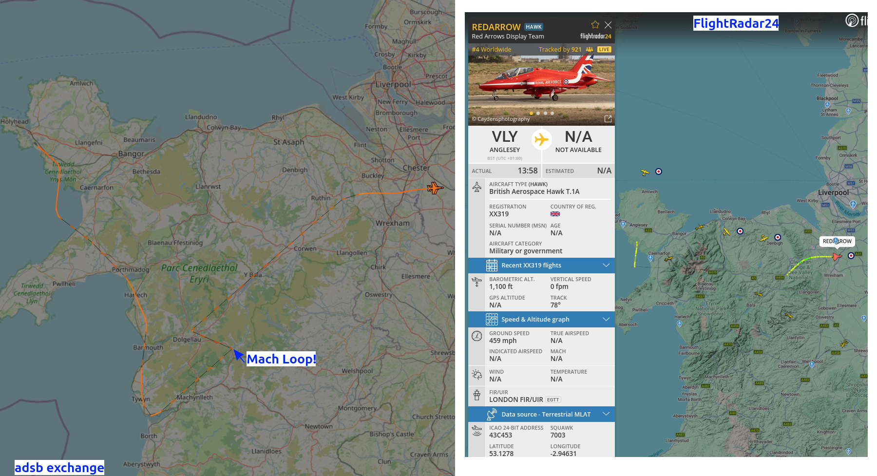
1. Flightradar24 (FR24)
Most consistent — start hereThe most widely used global flight tracker. FR24 often shows Red Arrows flights when their ADS-B transponders are active, and its clean interface makes it the go-to choice for casual followers. The Red Arrows sometimes go "dark" during displays, but transit flights are frequently visible.
- Clean, intuitive interface — easy to spot Red Arrows flights at a glance
- Search for "redarrow" to quickly isolate relevant flights
- Shows aircraft type (Hawk T1) and live position when transponder is active or in rang eof a receiver
- Aircraft can go dark if transponders are off, or if no FR24 receivers nearby during displays
- Move map to expected area
- Enable Military filter to reduce noise of other aircraft types
- Free tier has limited filtering options
- Search "redarrow" in the search box after the page loads. It can prompt you to view historic flight data if none are currently active.
- Zoom into UK airspace or known NOTAM locations to narrow focus
- Premium subscription gives better filtering and no ads
2. ADS-B Exchange
Best for military aircraftA non-commercial ADS-B aggregator that does not filter out military traffic — making it frequently the most reliable option for spotting Red Arrows movements, provided their transponders are broadcasting. Unlike commercial trackers, ADS-B Exchange shows nearly all military aircraft without suppression.
- Set Mode to 'U' (Show military only) & Move map to expected area
- Searching by callsign=redarrow01 or ?squawk=7003
- Shows military aircraft other trackers routinely hide or filter
- Broader receiver network with more frequent position updates
- Can manually filter by aircraft type (Hawk T1) or military category
- Interface is more complex and less polished than FR24
- No direct Red Arrows URL filter — manual setup required
- You must manually enable the military filter each session — press 'U' on the keyboard (or use the filter panel) to show military traffic; it doesn't persist between visits
- Lots of other military traffic can make finding the Reds harder once the filter is on
- Press 'U' immediately after the page loads to enable the military filter — easy to forget and the Red Arrows won't show without it
- Zoom tightly around display areas or RAF Waddington to narrow the field
- Use known tail numbers or squadron codes if available
This site has no affiliation with or responsibility for content on any of the above external services. They are linked because they have proven useful for tracking Red Arrows flights. NOTAM-based data from this site is often the most reliable indicator of planned routes regardless of whether the aircraft appear on live trackers.
The Red Arrows' official social media channels frequently post about upcoming displays, route changes, and behind-the-scenes content. Following them is one of the best ways to get last-minute updates.
- Check the Display Tracker the day before and morning of — formation transit NOTAMs are typically published 24–48 hours in advance.
- Check the route table in the tracker for waypoints near you — if the team is routing within a few miles of your location you may be able to see them en route.
- Display timings from NOTAMs are the most accurate available. The team typically arrive within a few minutes of the NOTAM time, but weather and ATC can cause delays.
- For displays, the restricted area NOTAM gives the display centre coordinates — use Google Maps to find viewing spots within 2–4 miles for the best view.
- Follow @RAFRedArrows on X on the day — the team often confirms displays or notes delays in real time.
- For formation transits, the jets typically fly at 250–2,000 ft AGL — low enough to hear and see clearly from the ground on a clear day.
Display Tracker · Latest News · Terms & Privacy